National Flowers and Trees, Mapped
Countries often choose national foods, drinks, animals, sports, and other symbols to celebrate and promote their unique identity and culture.
Then, there are plants, specifically flowers and trees. Yes, some countries have declared national flowers, like rhododendrons, roses, and orchids. Even more common are national trees, of which one stands alone, strong and powerful… kind of like an oak tree.
Let’s explore the 31 national flowers and 92 national trees of various nations.
View National flowers and trees in a full screen map
Rhododendrons, Roses, the Other 26 National Flowers
Flowers have long been used as symbols of a country’s identity and culture. When the 31 countries with national flowers made their decisions, they considered history, culture, and, of course, what was native to the nation.
Of 195 countries in the world, only 15% have declared a national flower. Yet, even still, we saw overlap in their choices: rhododendrons (3), roses (2), Lillies (2), poppies (2), and orchids (2) all were chosen by more than one country.
Rhododendrons are a symbol of resilience and strength, which may be why three countries selected them as their national flower. Nepal’s the Rhododendron arboreum, while both the Emirate of Caucasus and Kashmiristan choose the Rhododendron ponticum to represent them.
Roses are another popular choice for national flowers. Both England and the Maldives have selected types of roses for their national flower: the Tudor rose (an emblem) and Pink rose, respectively. Despite their names, neither South Korea’s Rose of Sharon nor Chile’s Lapageria rosea are roses. Like the rose, orchids are the national flower of two nations: Sikkim (Noble orchid) and Singapore (Orchid).
Meanwhile, lilies symbolize purity, innocence, and tranquility. You might think this makes them a popular national flower choice. While Sri Lanka’s Water Lily and Finland’s Lily of the Valley suggest this, the Lily of the Valley is a bit of a misnomer—it’s actually part of the asparagus family. Only Sri Lanka is truly represented by this particular type of flower.
Check out the rest of the national flowers on the map. Enjoy the simplicity of the Tiaré Flower (Cook Islands) or the bright bloom of Samoa’s Red ginger before moving on to national trees…
Interactive Maps Made Easy
Sign Up NowNational Trees Are Overwhelmingly Oak
Far more nations have designated national trees (92) than flowers (31). Also unlike national flowers, there’s a very common national tree: Oaks (18). Even so, there’s more than one Oak variety for nations to choose as their national tree.
| National tree common name | # | Countries |
|---|---|---|
| Oak, Pedunculate oak | 12 | Belarus*, Croatia, Denmark, England, Estonia, Latvia, Lithuania, Moldova, Poland, Romania, Serbia, United Kingdom |
| Oak | 2 | Germany, United States |
| Sessile oak | 2 | Ireland, Wales |
| Cork oak | 1 | Portugal |
| Golden oak | 1 | Cyprus |
The Pedunculate oak is the national tree of 11 countries—12 if you count Belarus, for which it is unofficial. All 12 are located throughout Europe, where this type of oak is native (it’s often referred to as the English oak or European oak).
However, not every European country is represented by the Pedunculate oak. Ireland and Wales’ national tree is the Sessile oak. Portugal has its Cork oak and geographically-Western-Asia yet culturally Southeastern European Cyprus chose the Golden oak. Meanwhile, Germany (and the U.S., though it’s decidedly not a European country) selected plain old oaks.
Palms, pines, and olive trees are also popular trees, as you can see in the table. You’ll find them all on the map… along with photos of each national flower or tree.
Display Images on Your Map
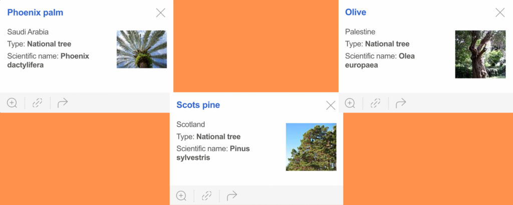
You may have noticed the thumbnail images we’ve included in this map, something you can do with your own BatchGeo custom map.
An image is worth a thousand words. That’s why we made it easy to include logos, icons, photos, or other imagery in your map itself.
Here’s how to do it:
- First, you’ll want to check that your images are small, not more than 150 pixels in either direction.
- Next, you’ll need to either upload your images somewhere, such as a blog or image provider, or pull in images that are already hosted online, like from Wikipedia (https://upload.wikimedia.org/wikipedia/commons/thumb/c/ca/Phoenix_dactylifera100_4209.JPG/120px-Phoenix_dactylifera100_4209.JPG).
- In your spreadsheet, create a separate column for your images, with a heading like “Images.” You can include a single image for every location.
- Add the URL for every image you want to include in that column.
Then, map your data, as usual, using our free mapping tool. You’ll be able to select the spreadsheet’s “Image” column when you “Show Advanced Options,” if BatchGeo doesn’t discover it automatically.
One note on hosted images: Sometimes Wikipedia or other sites will remove an image or restrict its access. To avoid this, you’ll want to host map images on Dropbox or a similar cloud image service.
