Mapping 50 Years of Bigfoot Sightings in the United States
For centuries, cultures around the world have told stories of large, wild, hair-covered humanoids. These legends take many forms, including the Yeti in the Himalayas, the Yeren in China, the Almas of Central Asia, and the Yowie of Australia. In the United States, these tales eventually coalesced around a figure now commonly known as Bigfoot, rooted in both Indigenous oral traditions and modern eyewitness accounts. While skepticism remains common, the persistence of these reports has led to organized efforts to document them.
A Brief History of Bigfoot Sightings
In the United States, Bigfoot stories are shaped by both long-standing folklore and more recent events. Indigenous nations across North America told stories of large, human-like beings living in remote landscapes well before European settlement, often sharing themes of strength, isolation, and avoidance of human contact.
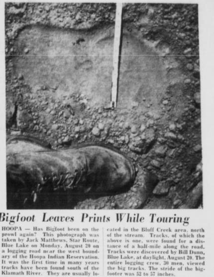
The name “Bigfoot” entered the public consciousness in 1958, after reports of oversized footprints near Bluff Creek in Northern California were covered by local newspapers. Less than a decade later, the 1967 Patterson-Gimlin film which was shot in the same region, brought national attention to the phenomenon.
As interest grew, efforts to document sightings became more systematic. By the late 20th century, organizations like the Bigfoot Field Researchers Organization (BFRO) began collecting firsthand reports and recording details such as location and timing, allowing sightings to be analyzed geographically and over time.
About the Data
This map is based on Bigfoot sightings in the U.S. from the past 50 years in the BFRO database, and is limited to reports that contain GPS coordinates and are classified as Class A or Class B.
Class A reports involve clear visual sightings with a low likelihood of misidentification, while Class B reports include less clear observations, such as distant sightings or distinctive sounds. Class C reports, which often rely on secondhand accounts, are excluded. Each marker represents a reported sighting.
View full screen map
Where Are the Most Sightings?
While sightings appear across much of the United States, the map shows clear concentrations in a small number of states. Washington leads the dataset with 22 reported sightings, followed by Ohio with 17, while California and Florida each report 15, ranking them among the most frequently reported states.
Interactive Maps Made Easy
Sign Up NowOther states appear regularly at lower volumes. Idaho, Georgia, and Virginia each contribute 10 sightings, reinforcing that reports are not limited to a single region. Together, these patterns show how sightings recur across locations and decades. Or, at the very least, where most Bigfoot spotters are keeping an eye out.
The Most Famous Bigfoot Sighting
No discussion of Bigfoot sightings is complete without mentioning the 1967 Patterson-Gimlin film. Shot near Bluff Creek in Northern California, the footage appears to show a large, upright, hair-covered figure walking through a forest clearing and quickly became one of the most recognizable images associated with Bigfoot.
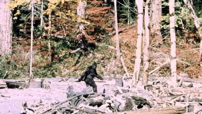
Despite decades of scrutiny, the film has never been conclusively proven or disproven. Supporters point to the subject’s movement and proportions, while skeptics argue it depicts a person in a costume. Regardless of interpretation, the film’s influence is undeniable.
Bluff Creek remains one of the most frequently referenced locations in Bigfoot history and continues to appear in modern reports. This illustrates how a single moment in history shaped decades of fascination and investigation.
Create Your Own Map
Mapping Bigfoot sightings doesn’t attempt to explain what witnesses encountered, but it does show where reports recur and how they’re distributed across the country. Viewing the data geographically offers a different way to explore a topic that has long lived in stories rather than spreadsheets.
If exploring unusual reports and phenomena is your thing, you may also enjoy our analysis of UFO sightings across the United States or a deep dive into strange sea creature encounters around the world.
Want to map your own list, timeline, or dataset? BatchGeo is the fastest way to turn a spreadsheet into an interactive map. If you’re not sure where to start, sample data is available to try it out. Explore your data today for free and see what insights a map can reveal!
