The 93 Island Nations of the World Mapped
Of the 195 countries around the world, almost half can be considered islands. To meet the definition, these must be non-continental land surrounded by water. Though these island countries all meet the water at every border, they can be very different.
Some are huge, others tiny, a few are ancient, and many are newer than you might guess. Importantly, 45 of the 93 countries are considered associated states, dependencies, or other notable territories, meaning that while they’ve declared their independence as countries, though it hasn’t been universally recognized as such. And as you’ll see on the map, they are all quite geographically distributed, but all of them qualify as island escapes.
We’ll cover the largest of the 93 total island countries, the smallest, and lots of other details about these places. While these island nations can be more susceptible to the effects of climate change due to their proximity to water, some house huge populations. Additionally, we’ll highlight the oldest (and youngest) of these isles and demonstrate how you can obtain a summary of all your map markers from the map below.
View Island Countries in a full screen map
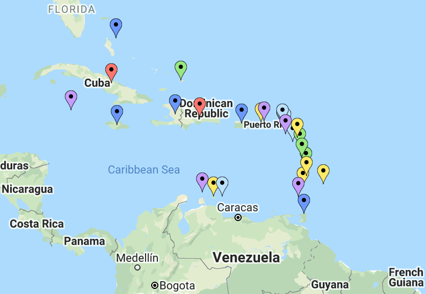
The map is based on this Wikipedia entry of island countries, which differentiates between widely-acknowledged countries and those that only consider themselves countries. You’ll also see each island’s size (one of the largest is 2.2 million km2!), with more details about individual islands below.
10 Largest Country Islands
Of the world’s established countries, 48 happen to be islands, AKA non-continental land surrounded by water. A reminder: the other 45 on the map aren’t universally considered countries. Let’s see which is the largest of these nations, along with the rest over 50,000 km2.
- Indonesia: 1,904,569 km2
- Madagascar: 587,041
- Papua New Guinea: 462,840
- Japan: 377,976
- Philippines: 300,000
- New Zealand: 268,680
- United Kingdom: 244,820
- Cuba: 109,238
- Iceland: 102,775
- Ireland: 70,273
Indonesia, the Philippines, and Papua New Guinea are clustered in Maritime Southeast Asia. To the North is Japan while two other island countries (the United Kingdom and Ireland) reside in the British Isles, not too far from Iceland.
Then there are the associated states, dependencies, and other notable territories that sprawl across hundreds of thousands of square kilometers. One of these is bigger than even the largest independent island country: Greenland. An autonomous territory of Denmark, Greenland’s 2,166,086 km2 is 1.14 times the size of Indonesia. As for the second largest of the associated state islands, Norway’s Svalbard is 62,045 km2. The rest range from 18,275 (New Caledonia) to only 12 km2 (Tokelau). But enough about the largest of these country islands, let’s scale down our focus to the smallest.
Interactive Maps Made Easy
Sign Up NowSmallest Isles
All the islands on the map may be countries but they come in a wide variety of sizes. Take Indonesia, the largest sovereign island country: it’s more than 90,000 times the size of the tiniest, noted on the list below.
- Nauru: 21 km2
- Tuvalu: 26
- Marshall Islands: 181
- Saint Kitts and Nevis: 261
- Maldives: 298
- Malta: 316
- Grenada: 344
- Saint Vincent and the Grenadines: 389
- Barbados: 430
- Antigua and Barbuda: 440
Of these independent island countries, half are located in the Caribbean: Saint Kitts and Nevis, Grenada, Saint Vincent and the Grenadines, Barbados, and Antigua and Barbuda. Now let’s move on from size to another metric.
Island Nations Population: Most & Least
Physical size isn’t everything. Other metrics make an island country stand out, like how many people choose to live there. The top ten most populated sovereign states have over 664 million residents combined, as you’ll see below.
| Name | Population | Area (km2) | Pop density (per km2) |
|---|---|---|---|
| Indonesia | 267,670,543 | 1,904,569 | 138 |
| Japan | 125,710,000 | 377,976 | 337 |
| Philippines | 101,398,120 | 300,000 | 295 |
| United Kingdom | 65,587,300 | 244,820 | 246 |
| Madagascar | 26,251,309 | 587,041 | 35.2 |
| Republic of China | 23,550,077 | 36,188 | 633 |
| Sri Lanka | 20,277,597 | 65,610 | 314 |
| Haiti | 11,439,646 | 27,750 | 350 |
| Cuba | 11,245,629 | 109,238 | 102.3 |
| Dominican Republic | 10,878,246 | 48,442 | 208.2 |
This table may appear a lot like the list of largest country islands (after all, Indonesia still resides on top). However, the Republic of China (also known as Taiwan), Sri Lanka, Haiti, and the Dominican Republic were added in place of Papua New Guinea, New Zealand, Iceland, and Ireland when it comes to the largest populations.
And while half of the smallest island countries (size-wise) are located in the Caribbean, it’s also home to three of the most populated (10+ million each): Haiti, Cuba, and the Dominican Republic. In Maritime Southeast Asia, Indonesia and the Philippines are two of the most populated island nations. Puerto Rico is the most populous associated state or territory with 3,690,923 people.
On the other hand, the island country of Singapore is highly populated when its relatively smaller size is taken into account. Discover other densely populated islands on the map or continue to learn about the least populated.
Least Populated Country Islands
Those who live in any of the following lesser independent populated island countries likely all know each other, so let’s take a look.
| Name | Population | Area (km2) | Pop density (per km2) |
|---|---|---|---|
| Tuvalu | 12,373 | 26 | 475.88 |
| Nauru | 13,635 | 21 | 649 |
| Palau | 20,000 | 459 | 43.6 |
| Saint Kitts and Nevis | 51,300 | 261 | 164 |
| Marshall Islands | 62,000 | 181 | 342.5 |
| Dominica | 71,293 | 754 | 105 |
| Antigua and Barbuda | 86,295 | 440 | 194 |
| Seychelles | 87,500 | 455 | 192 |
| Kiribati | 98,000 | 811 | 135 |
| Federated States of Micronesia | 101,351 | 702 | 158.1 |
Tuvalu and Nauru are the least populated country islands by a long shot. Tuvalu, which was the second smallest size-wise, is actually the least populated island while Nauru, the #1 smallest is the second least populated. Nauru is also one of the five islands with tiny populations located in Micronesia. Other islands that may be familiar from the smallest islands table include Marshall Islands, Saint Kitts and Nevis, and Antigua and Barbuda.
The folks with plenty of wide-open spaces (and the lowest population density) live in Iceland (3.1 per km2). Let’s move on from population size to another fact worth mentioning about the island countries.
Interactive Maps Made Easy
Sign Up NowOldest of the Island Nations
Now let’s highlight the island countries that were either established or gained their independence so many years ago.
- Japan (660 BC)
- United Kingdom (1707)
- Haiti (1804)
- Dominican Republic (1821)
- Cuba (1868)
- Philippines (1898)
- New Zealand (1907)
- Republic of China (1912)
- Ireland (1919)
- Iceland (1944)
The Philippines gained separation from Spain on June 12th, 1898 and the island country later earned its independence from the U.S. in July of 1946. Both the Dominican Republic and Cuba also had two different dates of establishment. Then there are the newest nations.
Young Island Countries
As for the youngest of the bunch, East Timor is the only island country established in the 21st century. Other more recent additions to the island country roster are Brunei (1984), Saint Kitts and Nevis (1983), Antigua and Barbuda (1981), Palau (1981), and Vanuatu (1980).
Then there’s 1979, the year of island inclusion. Five island nations were established that year: Marshall Islands, Kiribati, Federated States of Micronesia, Saint Vincent and the Grenadines, and Saint Lucia. To see how you can better see them, read on.
Get a Summary of Your Many Markers
It’s easier to spot trends in your data when you can see it on a map. But sometimes, even with the visualization of a map, you’re faced with too many data points to gain insights. With 48 sovereign island countries and 45 associated or territory ones—some so small, as we’ve shown, you have to zoom in to get a good picture of what’s going on.
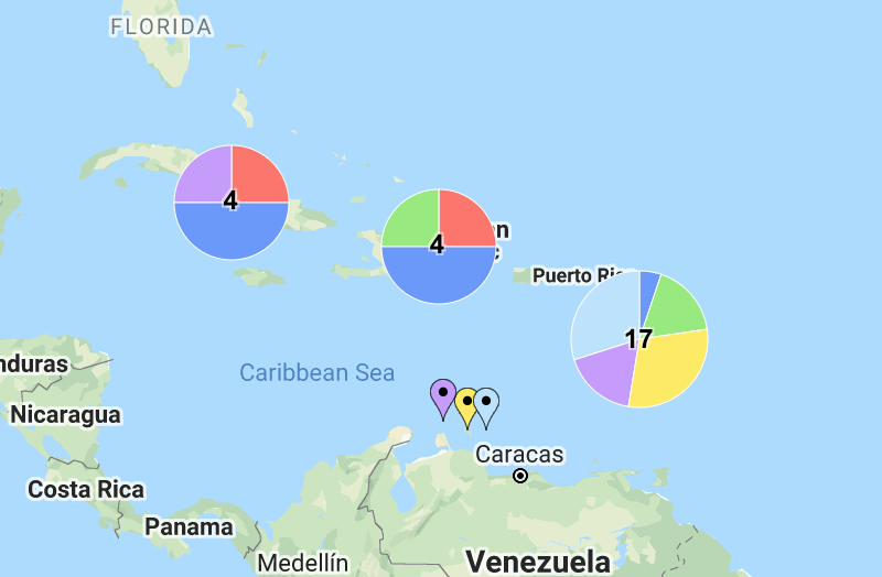
That is, unless you have summary markers to give you an idea of what’s below. A map with Cluster View enabled does just that. Learn more about how you can convert hundreds of markers into a reasonable number that still shares the underlying story or jump into it yourself with BatchGeo.
