BatchGeo Ranks #1 in Satisfaction and Popularity from G2’s GIS Software Awards
Thousands of other map-makers endorsed your choice of an easy, customized map tool. BatchGeo is highly-ranked in G2’s Annual Best Software Awards. The listing ranks the world’s best software companies and products based on reviews from real users. BatchGeo was a 2022 winner and customers have again provided the feedback to get us on the 2023 list of best Geographic Information System (GIS) software.
Not only did BatchGeo score in the top three of GIS software—we’re also the #1 highest performer in some of the most important categories, satisfaction and popularity.
Check out the best-ranked GIS software for yourself, or continue reading for an in-depth look at the rankings along with a demonstration of our winning software.
G2’s GIS Highest Performer in Satisfaction is BatchGeo
Many factors go into G2’s rankings. BatchGeo users helped it climb to the top of many of the categories. BatchGeo ranks #1 in popularity, but even more satisfying is also being #1 in satisfaction. That points to happy users who can quickly convert data into interactive maps.
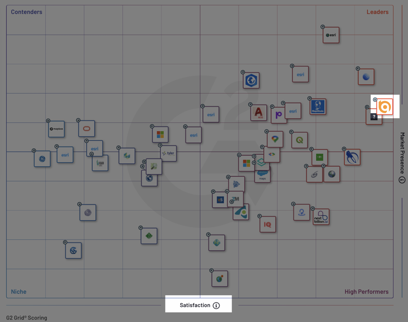
You can see how BatchGeo ranks in this category or note its place to the far right in G2’s top GIS Software Grid.
Most gratifying is that the satisfaction rankings are based on reviews, in which real users reported that BatchGeo is:
“Excellent for a quick graphical analysis, with the ability for more in-depth analysis.“
Another user said:
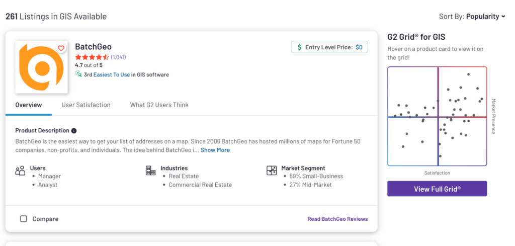
With over 1,000 reviews that average 4.7 out of 5 stars, BatchGeo is the best-reviewed and most-reviewed of the bunch.
BatchGeo Scores Among G2’s Top GIS Software Overall
GIS is a broad category, which includes downloadable desktop software and tools that programmers use to create maps with code. BatchGeo achieves the highest satisfaction and popularity, and is listed among some huge players in the overall rankings, called the G2 Score.
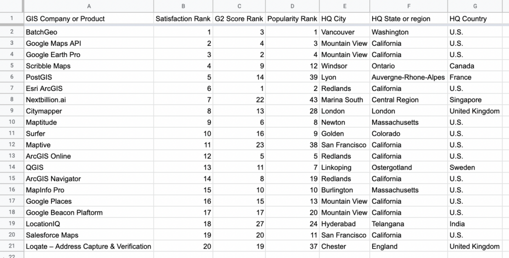
Of the 261 GIS companies and products ranked, the G2 Score winners were:
Interactive Maps Made Easy
Sign Up Now- Esri ArcGIS
- Google Earth Pro
- BatchGeo
- Google Maps API
- ArcGIS Online
BatchGeo is the only product in the top five that creates maps from spreadsheets and allows grouping and filtering based on your own data. In addition, BatchGeo outranks GIS software giants like Google Maps API and ArcGIS Online, plus 256 other tools.
G2 Score is a proprietary ranking algorithm, which takes into account many factors within real user reviews. The site also provides other sorting methods and scores. To be listed so high overall, BatchGeo performs well in many of these areas:
- Popular GIS software (#1)
- Highest satisfaction in GIS software (#1)
- Highest rated GIS software (#1)
- Best free GIS software (#1)
- Easiest to use GIS software (#2)
- Best overall GIS software (#3)
If you haven’t already given BatchGeo a try yourself, read on to walk through an example of how quickly you can map your own spreadsheet data.
G2’s GIS Satisfaction Winner HQs: Mapped
It’s an honor that BatchGeo customers ranked our mapping tool highly in so many categories. As we mentioned earlier, the satisfaction list is especially laudable, because it means BatchGeo users are happy with their experience. So, let’s take the data behind the top 20 G2 Satisfaction winners and map their company headquarters to show what’s possible with BatchGeo:
View G2’s GIS Satisfaction Winner HQs in a full screen map
All you need to make a custom map like the one above is some data and knowledge of copy and paste—no code required.
Here’s how we made it:
Whether your preferred platform is Excel, Google Sheets, or another option, start with a spreadsheet. We added the GIS companies that G2 ranked in the top 20 for Satisfaction with separate columns for each piece of information. Most important are columns for city, state, and country—or other location data.
From there, simply:
- Select (Ctrl+A or Cmd+A) and copy (Ctrl+C or Cmd+C) your data
- Open your web browser and navigate to batchgeo.com
- Click on the location data box with the example data in it, then paste (Ctrl+V or Cmd+V) your own data
- Check to make sure you have the proper location data columns available by clicking “Validate and Set Options”
- Select the proper location column from each drop-down
- Click “Make Map” and watch as the geocoder performs its process
Once mapped, trends you may have otherwise missed in “spreadsheet mode” become clearer. For example, we can see that of the top 20 GIS companies in Satisfaction, 13 are based in the U.S., including nine based in California, and two in Massachusetts.
Outside of the U.S., brands headquartered in the United Kingdom, Canada, France, India, Singapore, and Sweden also made it in the top 20 GIS companies.
There are plenty of insights waiting inside your own spreadsheets. Use our award-winning software to map your own data for free.
