Which State Has the Most State Parks? 2,280 Parks Mapped
When the weather is nice (and sometimes even when it’s not), nature-lovers break out their hiking sticks to take trips to the best state parks in the US. States offer protected state park status to places with picturesque beauty, historical importance, or recreational potential, so each and every state park is bound to impress. Depending on where you live, you could visit more than 160 different state parks and still not have seen them all. So, which state has the most state parks, and which state has the least? Where are the largest state parks in the US or the oldest state parks located? The map below contains information about Michigan state parks, Texas state parks, and all the state parks in between.
View State Parks in a full screen map
We gathered the data for this map of US state parks from Wikipedia. A note: some of the state park systems include beaches, state fish and wildlife areas, forests, historic parks, recreation areas, reservations, and other state-protected areas. However, we only included places with “state park” in the name, of which there were 2,280. Unfortunately, that doesn’t include the state parks in Alaska, Hawaii, and Montana, as the data was unavailable. That said, once you discover which state has the most state parks and exactly how many there are, it’ll take years to visit them all.
Which State Has the Most State Parks?
All 50 US. states have at least one state park. However, it’s to be expected that some states have more state parks than others. Whether motivated by larger populations or just a higher priority for natural spaces, the following list taken from the map answers the question of which state has the most state parks?
- New York
- Florida
- Washington
- Pennsylvania
- Connecticut
- California
- Texas
- Michigan
- Ohio
- Minnesota
Keeping in mind that due to lack of easily accessible data, those in Alaska, Hawaii, and Montana aren’t on the map, New York has the most state parks of any US state: 178. Of the 51 counties in New York with state parks, Suffolk County is the location of the highest amount of New York’s state parks (23). Jefferson County and Niagara County are also home to over 10 of New York’s state parks as well. When combined with Suffolk County, these three NY counties account for over 27% of the state’s state parks.
Interactive Maps Made Easy
Sign Up NowFlorida has the second-most state parks (148) while Washington has just seven state park less than Florida at 141. Florida has more counties with state parks (55) than New York but of them, Monroe County is the most concentrated with state parks: 10 are located there. There are 35 counties that house Washington’s state parks. San Juan County, King County, Jefferson County (a seemingly popular county name), and Mason County all hold 10 or more state parks.
Pennsylvania, Connecticut, and California own 110, 99, 90 state parks, respectively while Texas state parks add up to 78. Michigan state parks aren’t too far behind Texas state parks: Michigan has 77. To see how many state parks the rest of the top 10 states hold, check out the map. Otherwise, stay tuned for the states with the least state parks.
States With the Least State Parks
Just as some states are bound to have more state parks than others, the opposite must also be true. Several US states have very few state parks and the following are the 10 with the least.
- Nebraska
- Wyoming
- Nevada
- North Dakota
- South Dakota
- Rhode Island
- Alabama
- Delaware
- Arizona
- Kentucky
It appears Nebraska has the least state parks of the states on the map: just 8, though it’s worth noting it could be because Nebraska isn’t a very populous state. Following Nebraska’s low numbers are those in Wyoming, another state with a lower population. The state has just 11 state parks. Although is it any wonder? What state park can compete with Yellowstone National Park? Look here to see a map of other major US national parks.
Nevada, North Dakota, and South Dakota each have just 13 state parks, while Rhode Island has 14. The rest of the states on the list are home to 15 parks or more. To count them for yourself, use the map. Otherwise, stay tuned to learn the massive acreage of the largest state parks in the US.
Largest State Parks in the US
Sometimes bigger is better. If you’re planning a two-hour drive to a state park, it would be nice to have plenty of hiking trail options and views for days instead of just a small acreage. The following are the largest state parks in the US.
| Park name | County or city | State | Size (acres) | Year established |
|---|---|---|---|---|
| Anza-Borrego Desert State Park | San Diego | California | 585,930 | 1933 |
| Big Bend Ranch State Park | Presidio, Brewster | Texas | 311,000 | 1988 |
| Baxter State Park | Piscataquis | Maine | 209,501 | 1931 |
| Henry W. Coe State Park | Santa Clara | California | 89,164 | 1959 |
| Falcon State Park | Zapata, Starr | Texas | 83,654 | 1965 |
| Fakahatchee Strand Preserve State Park | Collier | Florida | 75,000 | 1975 |
| Custer State Park | Custer | South Dakota | 71,000 | 1919 |
| State Forest State Park | Jackson | Colorado | 70,838 | 1970 |
| Allegany State Park | Cattaraugus | New York | 64,800 | 1921 |
| Hennepin Canal Parkway State Park | Bureau | Illinois | 60,314 | 1970 |
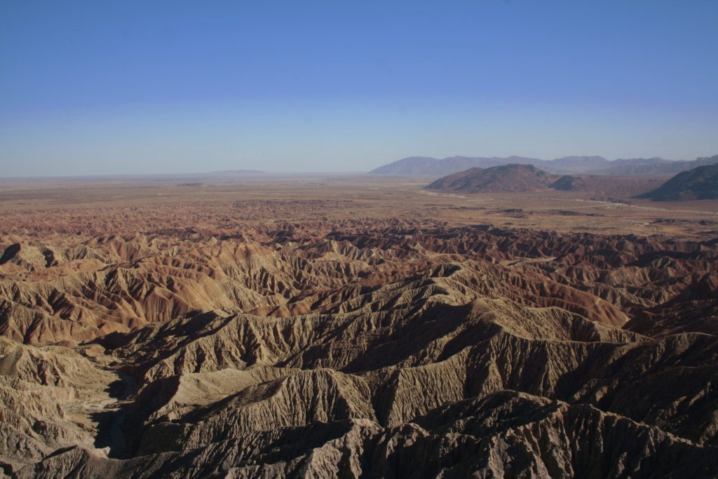
One of the largest state parks in the US is the Anza-Borrego Desert State Park located across the three counties of San Diego, Imperial, and Riverside, California. At nearly 600,000 acres, this state park is the size of over 440,000 football fields. Another of the largest state parks in the US is the Big Bend Ranch State Park of Presidio and Brewster, Texas. Like the Anza-Borrego Desert State Park, this 311,000-acre state park is so large it takes up more than one county. The last state park over 100,000 acres on the map is Piscataquis, Maine’s Baxter State Park. It’s 209,501 acres large.
The saying “everything is bigger in Texas” is true for Texas state parks. With both Big Bend and Falcon State Park, Texas state parks are certainly some of the largest state parks in the US; some might even say they’re the best state parks in the US. Now, several of the largest state parks in the US are quite old. For example, Allegany State Park was established way back in 1921. But that isn’t even the oldest state park on the map.
Interactive Maps Made Easy
Sign Up NowOldest State Parks
More than just the size of state parks, you can also sort the map by the years the parks were established. The years of establishment range from 1777 all the way up to 2019.
One of the oldest state parks on the map, the Princeton Battlefield State Park in Princeton, New Jersey, was technically established in 1777. As the site of an American Revolution battle between George Washington’s troops and British forces on January 3, 1777, it’s been around for a while. However, it seems this state park was officially deemed as such at a later date because New York’s Niagara Falls State Park is actually considered the oldest state park in the US. When you think of Niagara Falls, you’re probably unknowingly picturing the view from the Observation Tower at Prospect Point in the Niagara Falls State Park. Established in 1845, the state park offers a coveted view of all three waterfalls.

More state parks that have been around for some time include the Putnam Memorial State Park in Fairfield, Connecticut, Itasca State Park in Hubbard, Minnesota, and the Interstate State Park Chisago, Minnesota, among others.
More Grouping Options with BatchGeo
To view even more state parks over a century old, change the grouping option on the map to “Year established.” Since your data often contains more than just location, with BatchGeo, you can group your map by the extra data for even more insights. It’s helpful to be able to view the map grouped by different data, in this case, by both state park size and year established. When making your own maps, you can add and group by even more data, all with batchgeo.com.
