Microsoft MapPoint Alternative
Those who plot their location data on a map find it useful for both business and personal reasons. Doing so provides new insights you can only get from visualizing your data geographically. For example, you could create a proposal tracking map to see where your proposals are most accepted. Then you’ll know to concentrate your efforts there or increase your marketing in the other areas.
There are many uses for maps in daily life and there are just as many mapping software options. There’s ArcGIS and other desktop geographic information systems software, the Google Maps API, and web-based mapping tools that don’t require a software download nor coding experience. Yet even with all the software and web mapping options available today, avid map makers still reminisce about the days of Microsoft MapPoint. Whether you were a fan of Microsoft MapPoint or not, MapPoint inspired today’s mapping tools, including BatchGeo, which allows you to create custom maps like the one below.
View Household income, average clustering in a full screen map
Let’s go over what Microsoft MapPoint is, what happened to it, and what it did so that we can identify the best alternative to this pioneering mapping software.
What Is Microsoft MapPoint?
Microsoft MapPoint is a discontinued mapping software released in 1999 by Microsoft. A desktop application, Microsoft MapPoint allowed users to analyze data—custom or included—on a map. The Microsoft MapPoint graphics and draggable maps were an exciting first for the market and the software also supported integrations between its maps and Microsoft’s other products. However, Microsoft MapPoint is no longer readily available.
What Happened to Microsoft MapPoint?
Though popular in both the U.S. and Europe, Microsoft MapPoint was discontinued at the end of 2014, after 15 years on the market. By that point, users had access to web-based mapping tools that didn’t require a download. Microsoft continued to provide online support for Microsoft MapPoint until the summer of 2015, but then users needed to find a custom mapping alternative that offered similar features.
What a Microsoft MapPoint Alternative Needs
Any Microsoft MapPoint alternative should offer users the ability to do the things they loved to do with Microsoft MapPoint. These include:
Interactive Maps Made Easy
Sign Up Now- Find addresses/Geocoding
- Save/share work with other users
- Data mapping (manipulation of pushpin colors, visibility, highlighting)
- Points of interest
Because users could do all of the above with Microsoft MapPoint, an alternative must allow much of the same—though it wouldn’t be crazy for users to expect even more from a mapping tool so many years after the prime of Microsoft MapPoint.
How BatchGeo Compares to Microsoft MapPoint
Just as with Microsoft MapPoint, users of BatchGeo can find and geocode addresses, easily save and share work with others (they don’t even have to be BatchGeo users), and map and manipulate data and points of interest. BatchGeo is clearly a great Microsoft MapPoint alternative, though you can do even more with BatchGeo than you could with Microsoft MapPoint.
| Feature | Microsoft MapPoint | BatchGeo |
|---|---|---|
| Find addresses/Geocoding | ✔ | ✔ |
| Save/share work with other users | ✔ | ✔ |
| Data mapping | ✔ | ✔ |
| GPS guidance (Turn by turn) | ✔ | |
| Points of interest | ✔ | ✔ |
| No software download | ✔ | |
| Map grouping | ✔ | |
| Clustering | ✔ | |
| Heat view | ✔ | |
| Advanced or simple printing styles | ✔ | |
| Embed on a website | ✔ |
As an online mapping tool, creating maps with BatchGeo is done on your web browser; there’s no need to go through the hassle of downloading and installing any software. In addition to being easily accessible online, BatchGeo offers users ways to gain insight into their maps that even Microsoft MapPoint didn’t have. This includes clustering and heat view, among others.
Clustering
Map marker clustering is essential for users looking to avoid marker overload. Without the ability to cluster dense areas of markers together on a map, your maps can end up like this:
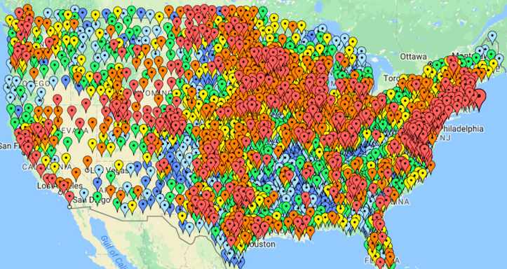
While colorful, this map offers almost no insight into data trends due to the hundreds of overlapping markers. Clustering solves this problem with larger summary markers to give you an idea of what’s “below” at closer zoom levels.
With Microsoft MapPoint, users could cluster their maps with additional paid add-ons such as MPCluster. However, BatchGeo’s online mapping tool offers users the ability to auto-cluster map markers for free. You can change your maps from overwhelming to useful with the click of a button:
View Household income, average clustering in a full screen map
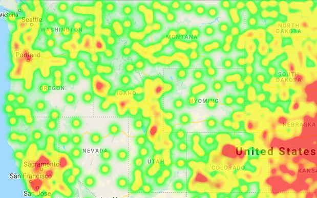
Heat View
In addition to clustering, BatchGeo users can also analyze their data via a map with heat view. Heat view is another way to identify areas with large amounts of markers on your map, like so:
Find out more about how heat view can turn up the heat on your data insights here. Before getting started with clustering and heat view, you must first create a custom map with BatchGeo.
Create Custom Maps With BatchGeo
To create custom maps that offer even more insight than Microsoft MapPoint did, follow the steps below.
- Open your spreadsheet
- Select (Ctrl+A or Cmd+A) and copy (Ctrl+C or Cmd+C) all your data
- Open your web browser and go to batchgeo.com
- Click on the location data box with the example data in it, then paste (Ctrl+V or Cmd+V) your own data
- Check to make sure you have the proper location data columns available by clicking “Validate and Set Options”
- Select the proper location column from each drop-down
- Click “Make Map” and watch as the geocoder performs its process
When you use BatchGeo to create your custom maps, you have access to the same mapping capabilities as Microsoft MapPoint—without the need to download software. Plus, map clustering and heat view help you to uncover even more insights into your data. And it’s all free for up to 250 locations per map. Explore how BatchGeo can improve your data mapping experience when you make your first map at batchgeo.com.
