Category: mapping

The 200 Highest Summits in the U.S.

Record-breakingly high mountain summits, which are the highest points of a mountain, are abundant in the United States — if you know where to look. In fact, the U.S. is home to over 200 mind-bogglingly high summits, including the highest in all of North America: Denali, located in Alaska. The locations — or should we say location — of the top ten highest summits may surprise you, as will the states with nearly identical massive summits that seem to be in really steep competition with each other.

View Highest U.S. Summits in a full screen map

To find out if the rest of the super-high mountain summits are condensed in a select few states or scattered across the country for all to see, check out the map above or read on.

To Summit Up Nicely: Ten Highest Summits

As we list off the ten very highest major summits in the U.S., you may start to see a pattern.

Rank Mountain Peak Mountain Range State Elevation (feet)
1 Denali Alaska Range Alaska 20,310
2 Mount Saint Elias Saint Elias Mountains Alaska 18,009
3 Mount Foraker Alaska Range Alaska 17,400
4 Mount Bona Saint Elias Mountains Alaska 16,550
5 Mount Blackburn Wrangell Mountains Alaska 16,390
6 Mount Sanford Wrangell Mountains Alaska 16,237
7 Mount Fairweather Saint Elias Mountains Alaska 15,325
8 Mount Hubbard Saint Elias Mountains Alaska 14,951
9 Mount Bear Saint Elias Mountains Alaska 14,831
10 Mount Hunter Alaska Range Alaska 14,573


That’s right, Alaska is home to every single one of the top ten highest summits in the U.S. Though the top ten all call The Last Frontier home, they are scattered throughout three different mountain ranges. The Alaska Range is home to 15 major summits in total. Three summits from the Alaska Range made the top ten list, including the very highest major summit not only in the U.S. but in all of North America: Denali.
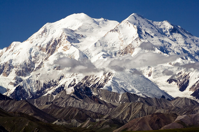
Photo of Denali by Nic McPhee

While the Alaska Range deserves bragging rights for its monster of a mountain Denali, the Saint Elias Mountain Range is home to 24 insanely high summits. The second of the three mountain ranges to take up real estate in the top ten list, the Saint Elias Mountain Range has the most major summits of any mountain range across the U.S.

Topping off the top ten is the Wrangell Mountain Range, where two of the ten highest summits in the U.S. reside. The Wrangell Range also has five other summits which made it onto the map, though they weren’t tall enough to make it to the top ten list. In total, Alaska is home to 49 out of the 200 highest major summits in the U.S.

State by State Summits

Despite the top ten highest summits list being utterly dominated by Alaska, and Alaska having almost 25% of the country’s major summits, Alaska isn’t home to the most major summits. That would be Colorado. Colorado is home to 88 summits, which is nearly half — 44% — of all of the highest summits in the U.S. The highest summit in Colorado is Mount Elbert, which has an elevation of 14,400 feet and ranks #14. Although, if we stuck Mount Elbert side by side with Denali, which rises to 20,310 feet, Elbert would seem pretty puny, comparatively. Colorado’s highest summits range from Mount Elbert to the aptly named Little Cone, at 11,988 feet.

The home of the second-most major summits, of course, is Alaska, with 49 huge summits, or almost 25% of the map. Next up is California with its 22 high summits, the highest being Mount Whitney of the Sierra Nevada Mountain Range. Mount Whitney stands 14,505 feet tall and is the first non-Alaskan summit to appear on the list at #11. Wyoming closes out the double-digit states with 14 summits.

As for the single-digit summit states, you can visit eight major summits in New Mexico, while you’ll find five in Utah. Nevada is home to the smallest summit on the map, #200 or Charleston Peak (11,916 feet), and has three additional summits, whereas, in Montana, you can see three major summits. If you’re lucky enough to be near the Washington area, be sure to check out its two high summits as they tend to make a big splash. Washington’s Mount Rainier, which is 14,417 feet, is in the top 20 highest major summits in the U.S. Plus, the Evergreen State’s second summit, Mount Adams, is actually a volcano! It can be sighted when hiking the Pacific Crest Trail. Though Mount Adams hasn’t erupted in more than 1,000 years, it’s not considered extinct yet, so watch out if your bucket list consists of hiking all of the highest major summits in the United States.
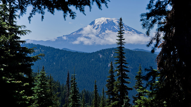
Photo of Mount Adams by Alex Butterfield

Twin Towers: Summits with the Same Height

If you group the map by rank, you can see that several of the summits share the same rank. These twin towers have the exact same elevation, so they’re tied. Check out the eight highest summits in the U.S. with the same height:

  • Wheeler Peak & Cloud Peak — #98
  • Lone Cone & Castle Mountain — #132
  • Hess Mountain & Mount Brooks — #193
  • Lituya Mountain & Haydon Peak — #198

Wheeler Peak, located in the Taos Mountains of New Mexico, and Cloud Peak in the Bighorn Mountains of Wyoming are tied for the 98th highest summit in the United States. These two summits are both 13,167 feet tall. As for the second pair of peaks, Lone Cone is not so alone. Colorado’s smallest summit, located in the San Miguel Mountains, has the same elevation as Castle Mountain in Montana’s Absaroka Mountain Range. Both Lone Cone and Castle Mountain have elevations of 12,618 feet, putting both of them at #132.

The summit creators certainly struggled to make up their minds when creating Alaska’s Hess Mountain and Mount Brooks. These two Alaskan summits have an elevation of exactly 11,940 feet, are both located in the Alaska Mountain Range, and are both in 193rd place. Finally, Lituya Mountain and Haydon Peak — also both in Alaska and both in the Saint Elias Mountain Range — share the same 11,924 feet elevation, tying them for #198.


The sky is the limit for the highest major U.S. summits and for all of the maps you can make with BatchGeo. Make your own map of other U.S. landmarks you think are cool, or check out some “map-spiration” from maps like the landmarks and milestones along the Appalachian Trail, locations along Route 66 you can still find, or the world’s largest map of the world’s largest roadside attractions.

Create A Proposal Tracking Map

Proposal-driven fields have more data than they realize. If you send out quotes or estimates on behalf of your business — whether it be for services or wholesale orders — don’t miss out on the insights a map provides. Since your success counts on improving the percentage of proposals that are accepted, keep track of where in the world or region your proposals go, where they are most accepted, and how potential clients heard about your business. Then, make a proposal tracking map. It’s easy with our spreadsheet mapping software, and we’ll walk you step by step through how it’s done.

View Proposal Tracking Map in a full screen map

Take a look at our example proposal tracking map above, where you can sort by “Proposal Status” or “How They Heard About Us.” Imagine what you can gain from making a similar map for your business, especially if you send out lots of proposals.

Track Proposals Like A Pro With A Spreadsheet

Step one of creating a proposal tracking map is to track your proposals — or your sales if you’d rather make a sales map. A spreadsheet is the perfect place to do so. Be it a Google Sheet or Excel, most any spreadsheet can easily be imported into BatchGeo once it has some data.

Start off by adding headings to your spreadsheet. Some potential column headings are:

  • Client
  • Location
  • Proposal Status
  • How They Heard About Us

A “Client” heading is necessary to identify the client you’re referencing when it comes to all the other good stuff. Plus, since we’re making a map, “Location” is essential. Fill this in with the location of your clients’ main HQs.

Some additional helpful headings are “Proposal Status” — whether or not your proposal for this particular client has been accepted, declined, or is still pending review. You can also add a “How They Heard About Us” column if you have that information. If you don’t, no worries! You can always start asking that of your clients and add it in later. All of these headings are going to get you the most out of the data you likely already have.

To make our example map, we offered cleaning services to people and places in California and border states. One of our potential clients, Eddard Stark, viewed our cleaning service proposal a while ago, and we’re waiting to hear back. While we wait, let’s add Stark’s data into our spreadsheet. Under the “Client” heading, we’ll add in Stark’s full name, and add that he’s located in the North…of California. We’ll mark the “Proposal Status” as Pending, seeing as we haven’t heard back from him. We do know he found out about us via an email campaign, so we’ll add that into our spreadsheet as well.

Now, we’ll add the rest of the potential clients we’ve sent proposals to in the recent past:

Copy & Paste Into BatchGeo

Once we’ve added in enough data, we can simply copy and paste the spreadsheet into BatchGeo. To do this, highlight all the data in the spreadsheet — don’t forget the ever so important headers! Copy the data by pressing Ctrl+C or Cmd+C on your computer’s keyboard, and then head over to our spreadsheet mapper to paste (Ctrl+V or Cmd+V) in the data from the spreadsheet. It really is that simple!

If you’re more of a visual person, this video walks you through the process of copying and pasting your data into BatchGeo:

Alternatively, follow these step-by-step instructions to get started:

  1. Open your spreadsheet
  2. Select (Ctrl+A or Cmd+A) and copy (Ctrl+C or Cmd+C) all your data
  3. Open your web browser and go to batchgeo.com
  4. Click on the location data box with the example data in it, then paste (Ctrl+V or Cmd+V) your own data
  5. Check to make sure you have the proper location data columns available by clicking “Validate and Set Options”
  6. Select the proper location column from each drop down
  7. Click “Make Map” and watch as the geocoder performs its process

Once you’ve completed the simple steps above, your proposal tracking map will look something like this:

View Proposal Tracking Map in a full screen map

You’ve Got Insights!

Armed with our new proposal tracking map, we can start to see geographical patterns we may not have otherwise noticed. For example, when we group by “Proposal Status,” we see that the majority of our proposals are accepted in Northern California. Now that we know we are more likely to get a gig in NorCal, we’ll start sending the majority our proposals there. Central and Southern California rarely accept our proposals, so with this knowledge, we could do one of two things. We could devise a marketing plan to gain more familiarity in these regions or bypass sending proposals there altogether and instead focus on the areas we’re more likely to add a client.

That’s not even all of the insights we gain from a proposal tracking map. If we group by “How They Heard About Us,” we can see that word of mouth gains us lots of clients in the North. No one has accepted a proposal based on our email campaigns or social media, so we may need to look into revamping those.


Now that your proposal tracking map is set up, don’t stop there! You’re already on a roll to improving the insights into data you already have, and there are many more maps to make that can help out your business. Easily create them all with BatchGeo. A map such as a map of customers or leads helps to illuminate trends, hot spots, and cold zones so that you can take action. Make another map today!

Daylight Savings Time On A Map

While it may feel like autumn leaves began falling forever ago, for the world’s Northern Hemisphere, summer just recently became a thing of the past with the conclusion of Daylight Savings Time (DST). In the United States and Canada, DST ends on the first Sunday in November, just a week after Europe says goodbye to DST, along with the many other countries that also observe the change around this time of year. Daylight Savings Time may allow us to accomplish more while the sun is up, thus helping us burn less of the midnight oil, but DST also causes a boatload of confusion twice per year. It can be a controversial topic as there are countries that avoid DST altogether, countries that religiously change their clocks twice per year, places that are planning on eschewing DST for the first time in 2019, and locations that tried implementing it long ago but then said, “No thanks, we’ll pass.”

View Daylight Savings Time by Country in a full screen map

The map above contains the Daylight Savings status of countries and places around the world, and here’s a hint: there are more countries that steer clear of DST than observe it. But if this is the case, why it was established in the first place?

Daylight Savings Time or War Time: The Background

Daylight Savings Time — also called Summer Time or Daylight Saving Time in many countries — has been in place for a while now. It officially came to be in 1918 during World War I, but the idea behind DST predates the first world war. While visiting the City of Lights (and rain, as Paris happens to be on the same latitude as Seattle) in 1784, Benjamin Franklin noticed that the folks of France were sleeping in long after the sun had risen and were closing their shutters to keep the light out. The Parisians were also staying up late into the night and wasting candles by doing so. Franklin’s solution to the wasting of perfectly good and workable daylight hours was to fire a cannon to wake everybody up at the same time. Unfortunately, that wasn’t super feasible, so Franklin died before seeing the light — so to speak — of Daylight Savings Time.

Later, other folks came to the same conclusions as Franklin, and by the time WWI began, countries were enacting DST to save fuel. Known as “war time” back then as it started and ended with each subsequent war, it later became a much more permanent part of our lives in 1966, when the U.S.’s Uniform Time Act called for war time — now “Daylight Savings Time” — to be enacted across the U.S. whether or not there was an ongoing war.

To Be on DST or Not to Be on DST: the Map Answers That Question

One hundred and six countries and other locations worldwide do not observe Daylight Savings Time at all, though 71 countries and places currently do observe it. For 64 of the 71 locations that are in the habit of changing their clocks, like the U.S. and Greece, DST has just recently come to an end. For seven DST-enacting places, though, like Australia and Brazil, their DST is just beginning, along with their summer.

However, there will soon be much less than 71 countries observing DST around the world. Of the 71 places that currently change their clocks twice per year, about 27 will join the masses that don’t in 2019. Countries within the European Union are getting rid of DST altogether, plus, four countries not considered part of the E.U. are also planning to jump on the bandwagon and eschew DST. This will leave just 40 places still observing Daylight Savings Time.

Here’s the master list of the 71 countries currently observing DST and how these E.U. changes could all play out in 2019:

  • Akrotiri and Dhekelia
  • Albania
  • Andorra
  • Australia
  • Austria
  • Bahamas
  • Belgium
  • Bermuda
  • Bosnia and Herzegovina
  • Brazil
  • Bulgaria
  • Canada
  • Chile
  • Croatia
  • Cuba
  • Cyprus
  • Czech Republic
  • Denmark
  • Estonia
  • Faroe Islands
  • Fiji
  • Finland
  • France
  • Germany
  • Greece
  • Greenland
  • Guernsey
  • Haiti
  • Holy See
  • Hungary
  • Iran
  • Isle of Man
  • Israel
  • Italy
  • Jersey
  • Jordan
  • Kosovo
  • Latvia
  • Lebanon
  • Liechtenstein
  • Lithuania
  • Luxembourg
  • Malta
  • Mexico
  • Moldova
  • Monaco
  • Montenegro
  • Morocco
  • Netherlands
  • New Zealand
  • Norwaynot a part of the E.U., but still getting rid of DST in 2019
  • Paraguay
  • Poland
  • Portugal
  • Republic of Ireland
  • Republic of Macedonia
  • Romania
  • Saint Pierre and Miquelon
  • Samoa
  • San Marino
  • Serbianot a part of the E.U., but still getting rid of DST in 2019
  • Slovakia
  • Slovenia
  • Spain
  • Sweden
  • Switzerlandnot a part of the E.U., but still getting rid of DST in 2019
  • Syria
  • Ukrainenot a part of the E.U., but still getting rid of DST in 2019
  • United Kingdom
  • United States
  • Western Sahara

Overall, most of Africa, Asia, Central America, and some South American countries closer to the equator have never observed Daylight Savings Time, nor has the majority of Oceania, except for New Zealand and Australia. The majority of Europe and North America currently observe DST, in addition to some Middle Eastern locations and the southernmost part of South America. However, all of this is set to change in 2019.

Why the European Union is Saying Au Revoir to DST in 2019

In September of this year, the European Commision in charge of law-making for the E.U. proposed to get rid of Daylight Savings Time. If this bill is submitted by the Commission, approved by parliament and all of the E.U.’s member states, then the very last DST time change will occur on Sunday, March 31st, 2019. In October of 2019, Europe will switch back to standard time for good. The reason for this drastic change? The opinion of the people. A survey conducted Europe-wide suggests that over 80% of those living in the E.U. want to scrap DST.

Getting rid of DST would see an end to the confusion that comes with asking folks to adjust their clocks twice per year because unless you’re looking at something like our map, you’re not always sure when and in which direction you should change your clocks. Additionally, no more DST means a decrease in car accidents around the time of the switch, since people will no longer have to adjust their energy levels to drive to work at 6 AM instead of 7 AM, and vice versa. Lastly, the lives of those working in transportation won’t have to amend schedules for the change any longer, which is great because transportation has enough issues already, like commute times. Well done, E.U.!

Ahead of the Clock

Photo by Wil Stewart on Unsplash

The European Union isn’t totally unique in its goal of removing Daylight Savings Time, nor is it the first to do so. If we count the two U.S. states that no longer observe DST, there are 69 places that had previously observed it, but no longer do.

The U.S., for example, saw both Hawaii and Arizona attempt to implement DST, but then both say “It’s not for us,” although for very different reasons. In Hawaii, DST simply isn’t necessary. Hawaii is so close to the equator that the sun is pretty consistent year-round in its rising and setting times.

Arizona, on the other hand, realized DST was doing the exact opposite for Arizonans than what it was intended to do: save energy. Arizonans actually ended up using more energy when DST extended their daylight hours because more daylight meant keeping the A.C. on for longer. After all, Arizona is known for its sizzling temperatures. Just a couple years after DST became a permanent fixture across the U.S., AZ opted out.

There are even some countries in Europe in which have beat the E.U. to the punch. Armenia, Azerbaijan, Belarus, Georgia, Iceland, Kazakhstan, Russia, and Turkey won’t have to change a thing come 2019, as these European countries are ahead of the game — or clock — and already no longer observe DST.


Mapping Daylight Savings Time by country made it easy to visualize which parts of the world DST affects the most — and why, as it’s now clear that most places near the equator don’t implement DST, and don’t really need to. Other helpful maps that make data easier to process by providing a visual include this map of the most disastrous natural disasters in world history.