Top 5 Mapping Apps of 2024
It’s easier than ever for you to bring location data to life. When you provide a geographic visualization to your website, news story, or sales process, you uncover additional meaning. And just about everything has a useful location context.
Anyone can put some markers on places, thanks to the abundance of mapping apps available. You have many different types of maps now at your fingertips. In some cases, you can change marker colors, overlay heatmaps, and filter by data about each place. However, all these features also add more complications: how do you choose which to use and how do you know if it does what you need? Whether you’re a seasoned cartographer or just starting your mapping journey, we’ve compiled a list of 2024’s top mapping apps to help you find the perfect fit for your needs.
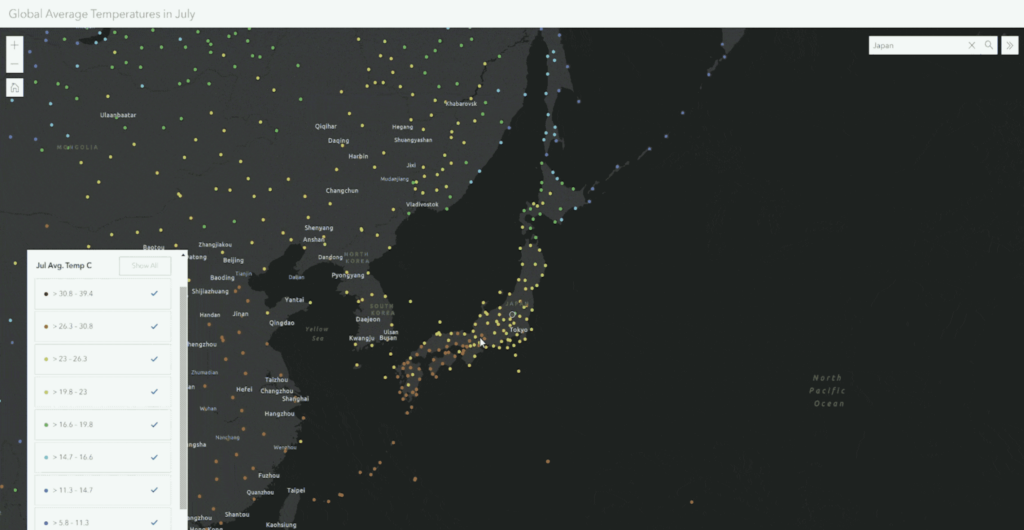
1. BatchGeo: Best for Entirely Customizable Google Maps
View Example Sales Map in a full screen map
BatchGeo sets itself apart as a user-friendly mapping tool that relies on the robust infrastructure of Google Maps, distinguishing it from many competitors in the market. With its user-friendly bulk mapping capabilities, BatchGeo caters to the needs of businesses and individuals alike, providing a convenient way to create interactive maps efficiently.
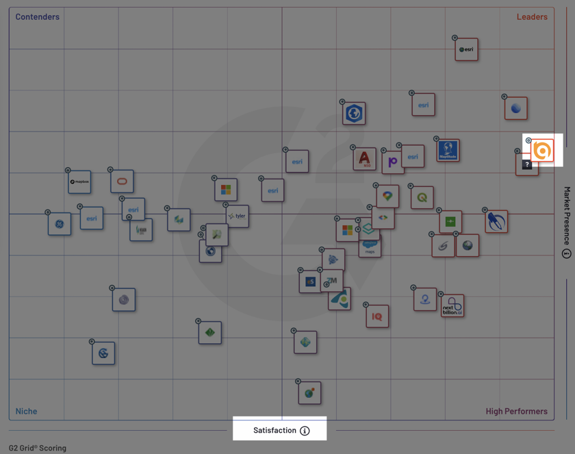
Ranking #1 in both satisfaction and popularity from G2’s 2023 GIS Software Awards, the platform’s integration with Google Maps offers users a familiar and dependable interface for their mapping endeavors.
Furthermore, BatchGeo’s complimentary plan is a notable advantage, granting access to a range of features that are typically reserved for premium subscriptions.
BatchGeo also enables seamless sharing of maps, allowing users to distribute them publicly or privately. Its diverse functionalities, such as creating heat maps, along with customizable map bases, marker shapes, and colors, enhance its adaptability.
For users seeking even more advanced customization options, BatchGeo offers a paid subscription that unlocks 100,000 markers per map, measurement and routing features, and more for you and a team of 10 users for one low price.
We recommend you start a BatchGeo trial and compare it to one or more of the options below.
2. Mapline: Best for the Basics
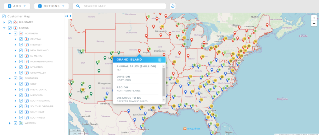
Mapline, like the others on our list, lets you mark places on a map. Its in-house map looks quite a bit different than Google’s, though Mapline adds routes and territories, as well as measurement features.
The Geospatial starter plan provides a sampling of the company’s mapping tools. It allows you to create maps, plot locations, and explore Mapline basics. You can only upload up to two datasets with 500 locations each, but you’ll be able to create territory and heat maps and draw a coverage radius.
Beyond its basic maps, Mapline has enterprise products for analytics, dispatching, scheduling, and operations. The pricing and functionality for these products are only available from Mapline Sales.
Nevertheless, the self-serve option is worth a test drive, if only to see how to create and navigate the maps. Some users find Mapline less user-friendly, with its interface a bit confusing compared to the next top mapping app. The paid products may provide a more focused offering, but you’ll want to make sure the underlying map does what you need.
3. Maptive: Best for Complicated Territory Maps
Maptive is a simple and easy-to-use choice for online mapping. It provides the basics we’ve come to expect from web mapping, like creating and sharing maps effortlessly.
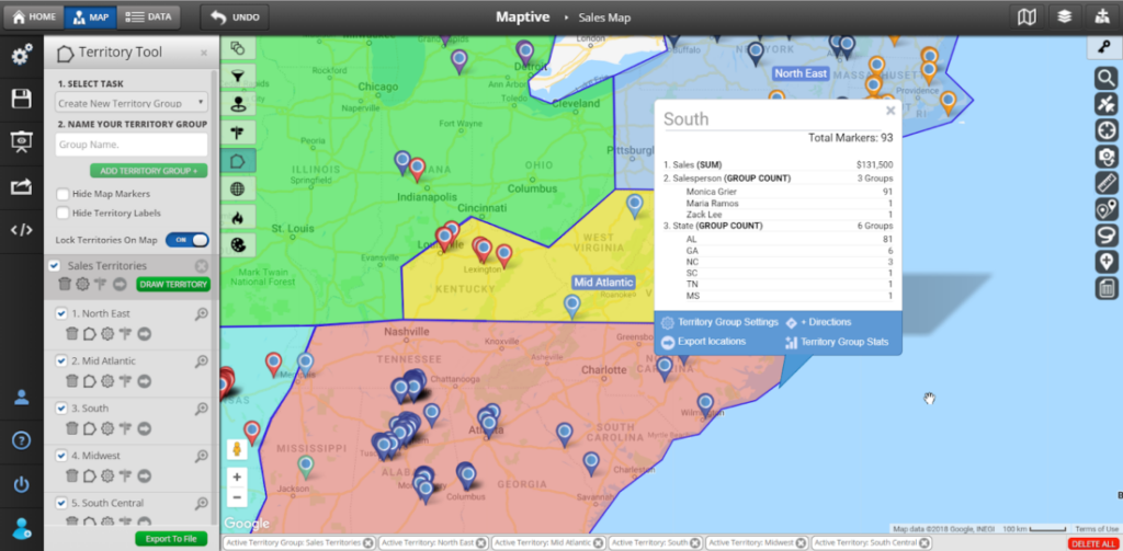
If you’re looking for complicated sales territories, you’ll want to try Maptive. It has polygon-drawing features to create territories, map geographic boundaries, and color-code each area. It adds heat maps, demographics data, and distance and drive time calculations.
To get the most out of Maptive’s most complicated features, you’ll likely need a team account, which is at least $5,000 annually for 10 seats. You’ll find a 10-day free trial to see if it works for your needs. Unless you need the complicated territories, this pricing may be a bit on the higher side. On the other hand, if you need GIS-level mapping needs, you might prefer to look at one of the next two options.
4. Maptitude: Best for Offline Use
Maptitude is firstly a desktop application to create maps. There are options to take these maps online, but much of the customization needs to happen on your computer. There are advantages to this approach, such as bringing external geographic data to your maps.
Another advantage of a desktop tool is that Maptitude enables you to create and view maps whether you’re connected to the internet or not. In fact, Maptitude’s examples focus on static visualizations, which you can share as images.
There is a Maptitude free trial to get you started, so you can answer for yourself if it solves your mapping problem. The pricing isn’t as simple as web-based software, with a number of options based on your needs. The entry point for the desktop software is $695 per user for a year of access.
5. ESRI ArcGIS Online: Best for Versatility
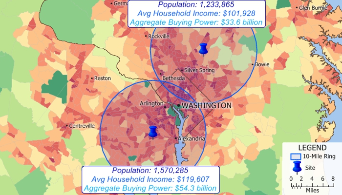
As the undisputed industry standard for cartography, we couldn’t wrap up our list of the top apps without mentioning ESRI ArcGIS Online. The well-known software caters to businesses and individuals that need robust spatial analysis and map creation tools. ESRI ArcGIS Online stands out for its unparalleled versatility, offering a comprehensive suite of features used by professional GIS engineers worldwide. From precise geolocation to advanced analytics, it is the primary tool for those who need maximum map customization beyond what’s possible with Google Maps.
ESRI ArcGIS’s downside lies in its steep learning curve, which often demands a large time investment. Additionally, its cost may pose a challenge, especially when compared to lower-cost alternatives that solve the most common mapping problems with web-based maps.
When it comes to mapping apps, there are many options. Mapline, Maptitude, Maptive, and ESRI ArcGIS Online all are excellent choices for specific needs. However, BatchGeo stands out among the most user-friendly and intuitive, thanks to its seamless integration with the familiar Google Maps platform and customization features that go beyond what Google Maps offers, all without the need for coding knowledge.
Give BatchGeo a try now and make Google Maps work for you – with faster geocoding, route optimization, password protection, 10 users at no additional cost, PDF support, and more.