Spanish-Speaking Countries Map

What do nearly 600 million people around the world have in common? Hablan español—that is, they speak Spanish. Included in that number is an impressive amount of native Spanish speakers, who, as children, learned to speak the language of their birthplace place. Spanish is only surpassed by English, Mandarin, and Hindi in popularity.

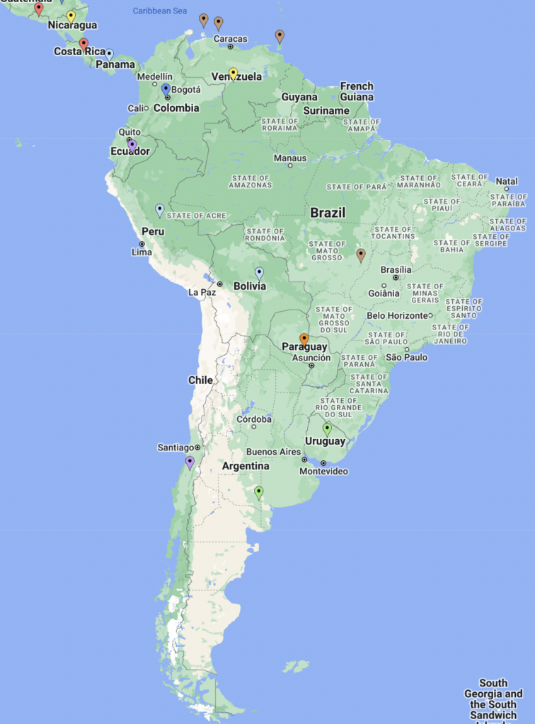
As such, you can find Spanish speakers on nearly every continent in the world, from Africa to Oceania. There are 45 countries where Spanish is either an official language or a significant Spanish-speaking population—and not only in Spain and Latin America, as you’ll find on the map below.

View Map of Spanish-Speaking Countries in a full screen map

Spanish-Speaking Continents

As the fourth most popular language in the world, Spanish is spoken across most continents. But which are home to most of the 45 Spanish-speaking countries?

  1. South America (11 Spanish-speaking countries)
  2. Caribbean (7)
  3. Central America (7)
  4. Europe (7, including Turkey)
  5. Africa (4)
  6. Oceania (3)
  7. North America (3)
  8. Asia (4, also including Turkey)

For nine of South America’s Spanish-speaking countries (Argentina, Bolivia, Chile, Colombia, Ecuador, Paraguay, Peru, Uruguay, and Venezuela), Spanish is an official language. Meanwhile, Spanish is spoken in Brazil and Trinidad & Tobago, though it’s not an official language. Within the continent, Colombia is home to the highest percentage of the population who speak Spanish natively (99.2%) while Paraguay is home to the least (68.2%).

While the majority of South American countries all have a high amount of Spanish speakers, technically North America is the continent with the most. Though many separate the Caribbean and Central America (including the source of our data), they’re both a part of the same continent as Canada, Mexico, and the U.S.

Of those three, only Mexico lists Spanish as its official language—and 96.8% speak it natively. Meanwhile, just 1.94% of Canadians, or 732,110 people speak Spanish whether natively or non-natively. Though a small percentage, Canada is the country with the 5th most number of Spanish speakers, for which it isn’t an official language. The U.S. boasts 17.15%—56,757,391 people—of the same statistic, which is actually the highest among the countries where Spanish isn’t an official language.

Altogether, 17 North American countries speak Spanish, and it’s the official language of 10 total, including many of the countries with the most native Spanish speakers we’ll discuss below.

Countries with the Most Native Spanish Speakers

While you can find Spanish speakers on every continent aside from Antarctica, there are certain places where you’d be hard-pressed to find someone who doesn’t speak Spanish. The countries where Spanish is an official language in the following table are home to almost 100% native Spanish speakers.

Country Flag % of population who speak Spanish natively
Cuba 🇨🇺 99.8
El Salvador 🇸🇻 99.7
Costa Rica 🇨🇷 99.3
Colombia 🇨🇴 99.2
Puerto Rico 🇵🇷 99
Honduras 🇭🇳 98.7
Uruguay 🇺🇾 98.4
Argentina 🇦🇷 98.1
Dominican Republic 🇩🇴 97.6
Venezuela 🇻🇪 97.3

If you’re visiting Cuba and don’t speak Spanish, you may have some trouble, seeing as 99.8% of the population speaks the language natively. That leaves just 22,660 of Cuba’s 11.33 million residents who aren’t native speakers.

Yet while Spanish is the official language of Cuba (as is the case for all of the top 10), it isn’t the only language spoken in the country. Many Cubans also speak Haitian Creole, Lucumi, Galician, and Corsican.

Additionally, El Salvador, Costa Rica, Colombia, and Puerto Rico also fall into the 99th percentile of native Spanish speakers, followed closely by the rest of the countries on the table.

You can see where the other countries fall when you group the map by “% of population who speak Spanish natively”, which includes details about the Spanish-speaking country in Africa where 74% are native speakers.

Washington DC Landmarks Mapped

The White House, the Capitol building, and a certain monument are some of the most famous landmarks in Washington DC and they’re in good company. The United States capital is named for Columbia, the female national personification of the U.S., and George Washington (the district’s oldest landmark also bears the first president’s name).

It’s also one of the most visited cities in the U.S. This may be due to the over one hundred landmarks in the district.

In celebration of when DC was officially incorporated as a city on May 3, 1802, we’re highlighting all of its national landmarks past, present, and future: parks, memorials, and monuments (including the White House, Supreme Court Building, and the United States Capitol) on the map below.

View Washington D.C. Landmarks in a full screen map

Types of Landmarks in Washington DC

The District of Columbia is home to 103 national landmarks, most of which are dedicated to events or people in American history. This includes the buildings of the three branches of U.S. government: the Capitol, White House, and Supreme Court, all of which are current national historic landmarks. There are 72 more DC landmarks in the same category, along with seven other sortable types on the map:

  • Current National Historic Landmarks (75)
    • Moved National Historic Landmarks (1)
  • Current National Memorials (12)
    • Future National Memorials (4)
    • Other National Memorials (3)
  • National Historic Sites (5)
  • National Monuments (2)
  • National Historical Parks (1)

Most common are, of course, national historic landmarks. However, this doesn’t make them any less worth visiting. To be designated as such, structures, districts, objects, and similar resources nationwide must meet criteria of national significance, including having a significant impact on American history, an association with a nationally significant figure, or an architectural style or significant development in engineering.

Along with the many current national historic landmarks, a national museum previously located in DC has since moved. The Army Medical Museum and Library was designated as a landmark In 1965, though it was demolished just four years later. Thankfully, the building’s collection was saved. It’s now displayed at the National Museum of Health and Medicine in Silver Spring, Maryland, albeit this museum is currently without official landmark status.

Check out the map to view national monuments, memorials (current, future, and other), and historic sites and parks. Now let’s go over which of these landmarks in Washington DC are the oldest.

Pre-20th Century: the Oldest Washington DC Landmarks

Washington DC was officially incorporated as a city on May 3, 1802. The district’s oldest landmark was designated 83 years later in 1885 (the Washington Monument). Let’s take a closer look at the oldest Washington DC landmarks in the table below.

Landmark Date designated
Washington Monument February 21, 1885
Lincoln Memorial May 30, 1922
Thomas Jefferson Memorial April 13, 1943
City Hall / D.C. Courthouse December 19, 1960
Decatur House December 19, 1960
Octagon House December 19, 1960
St. John’s Church December 19, 1960
Tudor Place December 19, 1960
United States Capitol December 19, 1960
White House December 19, 1960

The Washington Monument is the oldest landmark in the nation’s capital. Its designation was followed by two more DC landmarks dedicated to past presidents in 1922 and 1943.

But perhaps the most interesting of the ten oldest DC landmarks are the seven that were designated on the same date in December 1960. Included are the White House, Decatur House across the way, and St. John’s Church, nicknamed the Church of the Presidents.

However, the date a building is officially named a national historic landmark often isn’t when it was constructed. In fact, there can be over a hundred years between. For example, construction on the White House began in October 1792 and was finished in November 1800. This makes the President’s residence older than the city itself.

Moving on, let’s look at the latest landmarks in Washington DC.

Most Recent Monuments & Memorials

On the other hand, the district’s most recent landmark addition is the 2021 Pan American Union Headquarters. The majority of the new DC landmarks were designated throughout the 2010s:

  • Pan American Union Headquarters (2021)
  • Dwight D. Eisenhower Memorial (2020)
  • National Native American Veterans Memorial (2020)
  • Belmont-Paul Women’s Equality (2016)
  • World War I Memorial (2014)
  • Congressional Cemetery (2011)
  • Martin Luther King Jr. Memorial (2011)
  • Lafayette Building (2005)
  • United Mine Workers of America Building (2005)
  • World War II Memorial (2004)

If you feel like you’ve already visited DC after clicking through the map, check out Hawaii’s landmarks or those in Washington (state). Otherwise, you can start mapping your own state’s landmarks at batchgeo.com.

Store Locator Creator using BatchGeo

In the modern era, customers find websites before physical locations. Yet, many purchases are made at a local brick-and-mortar place. Whether your company is a chain, or you distribute to many different stores, your website can help connect customers to your products in person with a map of store locations.

Save your customers from opening yet another tab or picking up the phone. You can provide them with an easy-to-use, searchable map right on your website:

View Apple Store Locator in a full screen map

Here’s a step-by-step guide on how to do using our mapping tool to create a store locator.

Add Your Store Locations to a Spreadsheet

The first step of creating a store locator is to create a spreadsheet of your store or business locations. You might have even already compiled this information elsewhere, though you’ll want to make some adjustments when you transfer it into Excel, Google Sheets, or any other spreadsheet tool.

Ensure that each piece of data is in its own column, including:

  • Address
  • City
  • State
  • Zip code
  • Store Name
  • Phone Number

If you have many locations to map, that’s fine. You can add up to 25,000 locations per map with BatchGeo Pro.

Now let’s see how to display your store locations on a customizable map.

Copy and Paste Your Store Data to Make a Map

With your locations added to a spreadsheet, the next step in creating a store locator is to copy and paste your data into our tool.

To do so:

  1. Select (Ctrl+A or Cmd+A) and copy (Ctrl+C or Cmd+C) your data from the spreadsheet
  2. Open your web browser and navigate to batchgeo.com
  3. Click on the location data box with the example data in it, then paste (Ctrl+V or Cmd+V) your own data
  4. Click “Map Your Data” and watch as the geocoder turns your store addresses into coordinates

You can check to make sure you have the proper location data columns available by clicking “Set Options.” There are several customizations you can opt to make under “Show Advanced Options,” including map style, marker colors, shape, and more.

Once you’re satisfied, click “Save & Continue,” though you can always make edits later.

Go ahead and give your map a Title along with an optional description on the following page. Add your email if you don’t already have an account so that you’re able to come back to your map in the future. You’ll also want to set your privacy/share settings to Public, which will allow anyone to see your map.

Finally, perhaps the most important part: select “Store Locator” as your “Map Mode.”

View Apple Store Locator in a full screen map

Hit “Save Map,” and there you have it! The map displays all of your location information, phone numbers, and names of the stores. With your map complete, let’s finally see how we can add it to your business website.

Embed Your Store Locator Map on Your Website

So far, we’ve created a spreadsheet of your locations and turned it into a store locator map. Now, we’ll show you how you can add the same store locator map to your website.

Now, you could just copy the link of your map and paste it straight to your website, but we’re gonna take this one step further and embed it.

Right-click your store locator map and select “Edit Map.” Scroll down until you spot “Embed Code.” Copy the code and paste it into your website editor. For example, if you’re using WordPress, choose a “Custom HTML” block and paste it there.

More than just embedding it onto your website, you can also make it possible for users of your map to search for the location of your store that is closest to them with an additional setting.

Enable Users’ Ability to Search for Their Nearest Location

On the same “Edit Map” page as we previously described, scroll down to the “Locator” setting and enable it. When enabled, this will show a search bar on your map, which can be used to filter results and find the nearest to a given location.

Users of your map will be able to type in their location (such as New York City) and the map will automatically pull up which of your stores are closest to them.

Make your own store locator and display it on your website for free at batchgeo.com.