Drag Racing in the US: Auto Tracks
From horse races to racing greyhounds—and even camels—a racetrack can host many different types of events. Even human sports like Bobsleigh (bobsledding’s official name) take place on a race track. But most associate racetracks with motorsports like auto racing.
Auto racing has existed since the car’s invention. From the Auto Club Raceway at Pomona to zMAX Dragway, let’s get ready, set, go down the road of the oldest and newest drag racing automobile race tracks and where they’re located, as displayed on the map below.
View U.S. Auto Tracks in a full screen map
The map is fueled by Wikipedia’s List of auto racing tracks in the United States. Sort it by each track’s opening year, what it’s made of, its length, and involvement in major racing series. Or, keep your foot on the gas to read more about each category.
Oldest & Newest Auto Tracks
Built in the ’50s, the oldest automobile race tracks in the U.S. have seen millions of fans walk through their doors.
- Auto Club Raceway at Pomona (1951)
- Great Lakes Dragaway (1955)
- Bunker Hill Dragstrip (1956)
- GALOT Motorsports Park (1957)
- Bandimere Speedway (1958)
As the country’s oldest track, the Auto Club Raceway at Pomona has always hosted the traditional season opener, NHRA’s Winternationals. On top of that, this Pomona Raceway has also been host to the last race of the season, the NHRA Finals, for over 35 years, making it perhaps one of the most famous dragstrips in North America.
In addition to the five oldest noted above that were built between ’51-’58, three more racing tracks were built that same decade. These include Bremerton Raceway, Kil-Kare Raceway, and Roxboro Motorsports Park, all of which were constructed in 1959.
Newest
Only two race tracks were constructed this century: Thornburg, Virginia’s Dominion Raceway (2016) and Concord, North Carolina’s zMAX Dragway (2008). zMAX Dragway’s construction brought the number of race tracks in North Carolina up to four, making it the U.S. state with the most auto tracks.
American Race Tracks Locations
Let’s look into where these tracks are located around the country. For starters, no city is home to more than one race track (that would be a lot of racing!) So where are they congregated?
Interactive Maps Made Easy
Sign Up Now- North Carolina (4 race tracks)
- Florida (3)
- Ohio (3)
- Illinois (3)
Auto racing is big Southeastern states like North Carolina and Florida. The previously mentioned zMAX Dragway is proof of that, along with Rockingham Dragway, Roxboro Motorsports Park, and GALOT Motorsports Park—all in N.C. As for Florida, there’s Bradenton Motorsports Park, Gainesville Raceway, and Palm Beach International Raceway.
We can’t forget about the Midwest. Summit Motorsports Park, National Trail Raceway, and Kil-Kare Raceway are all located in Ohio while Illinois is home to Route 66 Raceway, World Wide Technology Raceway and Byron Dragway. And the following 10 states have double tracks: Wisconsin, Washington, Virginia, Texas, Tennessee, Pennsylvania, Oregon, Indiana, California, and Alabama.
Despite these multi-track states, racing locations aren’t usually very near each other. In the next section, we’ll show how BatchGeo can help you measure distances—whether raceways or your own data.
Calculate Distance Between N.C. Tracks & Beyond
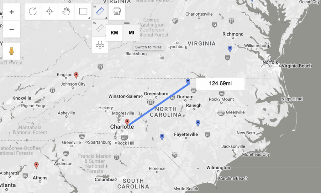
As we’ve mentioned, the Tar Heel State is home to two dragways and two motorsports parks, for a total of four race tracks. So let’s examine how many miles are between them.
To, determine the distance between two markers, right-click the BatchGeo map to enable Advanced Mode and then select the ruler in the top left corner of the map. Opt for the measuring tool and choose your preferred metrics. Next, draw a line from Point A to Point B and BatchGeo will let you know how far apart they are.
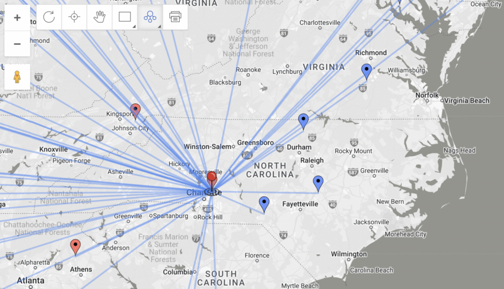
But we can also see the distance from one marker to every marker on the map with just the click of a button. Within the same ruler dropdown, select the second option: marker measure tool. Then, place your main point (whether atop mapped marker or anywhere else) to see distance from every point you previously plotted to that spot.
Don’t just eyeball distance—BatchGeo makes it easy for you to precisely measure distance between points at batchgeo.com.
