Author: Adam DuVander

How to Enter Latitude and Longitude into Google Maps

Every point on the earth can be described by two numbers, neither larger than 180. Most of us even have devices that will tell us the exact point where we’re standing. The set of numbers are coordinates, referred to as latitude and longitude. Alone these numbers aren’t particularly useful. We instead want to add them to a map. There are many ways to enter latitude and longitude into Google Maps and other online maps. We’ll cover many of them below and even help you discover where you can find some coordinates to try it out yourself.

For now, let’s say you have a latitude and longitude and you’re ready to see it on a Google Map.

Use Google Search

Google Maps display of latitude and longitude coordinates
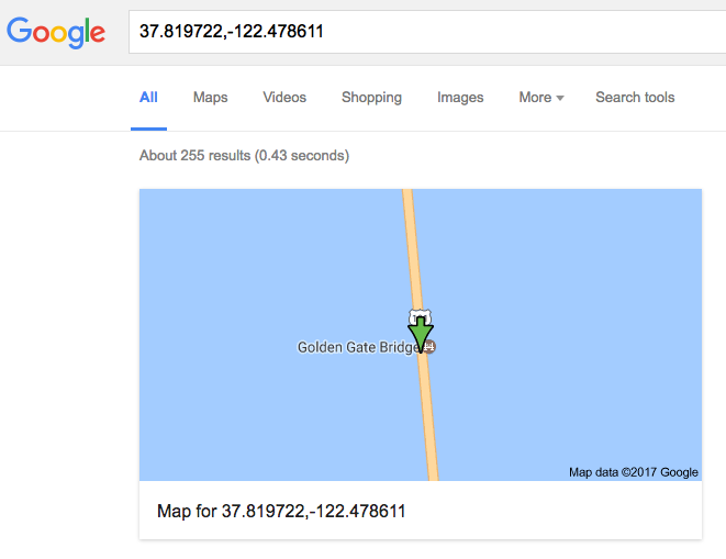
That’s right, you can go straight to the simplest page on the Internet—google.com—and enter your latitude and longitude into the search box. Usually coordinates are listed with latitude first, then longitude. Double check that is the case and that you’ve included a comma between the numbers.

Let’s say these are your coordinates: 37.819722,-122.478611

At the top of the search results, you’ll see an image representing those coordinates on a map. In this case, that’s somewhere along the iconic Golden Gate Bridge in San Francisco! Click the image and you’ll be taken to the full Google Maps version of the same location. There’s a single map marker at the location you searched.

In fact, you can go directly to Google Maps and use its search. You can even get directions from one set of coordinates to another. Google Maps treats latitude and longitude like any other search term, allowing you to specify the exact location.

You can even link to Google Maps by latitude and longitude point. For example, here’s the quickest way to the map at the Golden Gate coordinates:
https://www.google.com/maps?q=37.819722,-122.478611

Including more than one or two markers on a map is a bit more complex. Before we get to that, where do you find all these coordinates to map in the first place?

Find Latitude and Longitude Points

Before you can put latitude and longitude on a Google Map, you need to find the numbers. Once you start looking out for them, you may notice them all over the place. Any time you use maps or other location apps on your smart phone, there are latitudes and longitudes under the covers, for example.

You can get a GPS app for your phone that will show your current location. To be the most readily useful, ensure you can receive the coordinates in decimal notation. Often, a GPS app (such as iPhone’s Compass app) will display in degrees. To be ready for Google Maps, you’ll probably have to convert those coordinates, so it’s best to find an app that has them ready as a pair of decimal numbers.

Wikipedia example of latitude and longitude coordinates

A great way to find latitude and longitude points without having to visit the location is to use Wikipedia. Most articles for cities, places, and landmarks have the coordinates listed in the upper right of the page. By convention, Wikipedia shows these in degree notation. However, click the coordinates and you’ll be taken to a page that provides the decimal conversion.

Lastly, Google provides this tool, embedded below

You can enter an address, postal code, landmark, or other location and get its latitude and longitude values. You can even explore a map, find the spot you want, and click. Try it above.

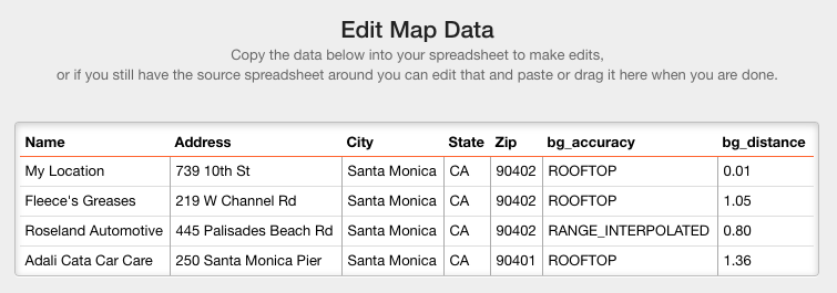
Create a Google Map Listing Many Locations

It’s one thing to plot a single point on a map or to discover the coordinates for all your favorite places. Next you need to get them all on a map. For programmers, Google includes a Google Maps API. As we discuss in our tutorial, that’s definitely the hard way to map multiple locations.

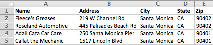
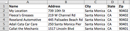
Most users of our mapping tool simply have a spreadsheet with addresses. Simply copy and paste the entire spreadsheet and we’ll create a map that you can view online, embed in your website, and share with others.

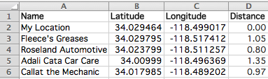
The tool also works with latitude and longitude points. Just include them as two columns in your spreadsheet, then copy and paste all your data in. We created a more detailed walkthrough of mapping latitude and longitude points using BatchGeo, which goes through the process step by step.

Are you ready to try it out? Create your first map right now.

Calculate Distances Between Two Addresses or Points

The shortest distance between two points is a straight line, but how long is that line? When it comes to those two points, you may know them as GPS coordinates, or you may only have addresses. Even if you know each latitude and longitude, the math behind the distance calculation is complicated. There are several approaches and tools you can use to make it easier, even bringing the calculations to every row of a spreadsheet. We’ll cover a few options below to get you started with calculating distances.

Many Distances from a Single Place

Calculating a single distance is easy. In fact, we do it all the time using Google Maps and other directions services. Of course, that distance is typically a driving distance instead of the straight line distance. Nevertheless, when you find yourself needing to know multiple distances, the most common reason is you want to find out which locations are closest to single point, such as your current location.

Let’s say you have a spreadsheet of addresses of your city’s mechanics. Your car is broken down and you don’t want to have to push or tow it any farther than necessary.

Santa Monica Mechanics

Add your address, or the address of wherever you want to use as a reference location in the first row of your spreadsheet, just after the header row.

Santa Monica Mechanics (with my location)

Now highlight and copy your entire spreadsheet (including the header row) and paste it into our simple map making tool. Click Validate and Set Options, then choose Advanced Options. Check the option to calculate distance from the first address. Then click Make Map.

View Santa Monica Mechanics in a full screen map

Now when you see the map, the distance is listed along with the other data with each marker. Since we used letters to label the markers, we know that Marker A is our first row, which is used to calculate the distance for all the other markers.

Break Out Your Digital Measuring Tape

Calculating the distance across all your locations is incredibly useful. Yet, sometimes you want to perform ad hoc measurements between many markers. That’s where the measuring tools that are part of BatchGeo’s Advanced Mode come in handy.

You can check whether Advanced Mode is active, and activate it if necessary, using the Pro menu in the upper right corner of any map. You must be a BatchGeo Pro member and logged in to use Advanced Mode. If Advanced Mode is active, you’ll see several buttons near the zoom controls in the upper left corner of your map.

Manually measure distances

Select the measuring tool, the button with a ruler icon. The hand cursor will become a plus sign target. Now click and hold where you want to begin a measurement (such as one of the markers). Next, drag the cursor to the end of your measurement. As you drag, you’ll see the current distance from the initial point to the current cursor. To switch between metric and imperial systems, click the scale on the bottom right of the map.

Deploy the Haversine Formula in Your Spreadsheet

The absolute best way to view geographic data is from a map, which is why BatchGeo lets you map Excel data (and other spreadsheets) with our simple copy-paste interface. However, if you need the distances in your spreadsheet directly, you’ll need to include a complex series of functions.

Santa Monica Mechanics (with distances)

Let’s say you know the latitude and longitude points of those mechanics stored in columns B (latitude) and C (longitude) of your spreadsheet. Using a formula derived from this site, you could calculate the distance from Fleece’s Greases (row 3) to your location (row 2) using this formula:

=3958*ACOS(SIN(B$2*PI()/180)*SIN(B3*PI()/180) + COS(B$2*PI()/180)*COS(B3*PI()/180)*COS(C3*PI()/180-C$2*PI()/180))

You can change the 3,958 — the approximate radius of the earth in miles — to another unit, such as kilometers (6,371), meters (6,371,000), or feet (20,898,240). The rest is advanced math based on the spherical law of cosines. The important parts are the B$2 and C$2, which ensure you’ll compare other rows in the spreadsheet to your location, affixed in that second row. When you copy and paste this formula, the other fields will update to correctly reference the current row.

The haversine formula only works if you know your latitude and longitude points. If all you have is addresses, BatchGeo can help: create a map with measurements from a single distance (as in the first section above), and copy the data back out to your spreadsheet. Go to edit your map, copy the entire data, and you’ll see the distance as the final column when you paste into an empty spreadsheet.

Edit Map Data to Get Distances

The best part is that your map will still be there as a visual representation of the same data. Naturally, we think a map is a great way to augment the data in your spreadsheet. These different methods of calculating distances have varied levels of difficulty and usefulness, depending on the data you have available. Why not try creating a map now for free?

100 Years Later: Here’s a Map of Major 1917 Events

It’s been 100 years since 1917, a year clouded with events mostly centered in Europe. World War I had dragged on since 1914 with little hope of peace or victory. Though involved in the war, Russia had a lot more to consider when its government collapsed in February. Many of the events of 1917 fall into these two categories, but as you’ll see on the map below, there was a lot going on that year. Peruse the map, or read on for highlights from one hundred years ago.

View 1917: Map of Historical Significance in a full screen map

World War I

The Western Front is the most well known area of warfare, but it was hardly the only place to see action. The west was the primary battlefield, but remember the war initially broke out due to the assassination of Archduke Franz Ferdinand in eastern Europe. Among the countries with WWI-related events, based on Wikipedia’s list, are Belgium, Brazil, Canada, China, Egypt, England, Estonia, France, Germany, Iraq, Ireland, Isle of Wight, Israel (then Palestine), Italy, Jordan, Mozambique, Russia, Scotland, Serbia, Spain, Ukraine, and the United States. There’s a good reason it became known as a World War.

Using the map above, click the WWI category to restrict only those events related to WWI on the map. Now you’ll see how widespread the markers are, though there’s clearly a cluster around Europe and the Middle East. Most of the far-flung locations are declarations of war from the likes of the United States, Brazil, and China. Interestingly, one outlier was actually a battle. In November, Germany and Portugal battled near the border of modern-day Mozambique and Tanzania. Outside of very northern Egypt, on the Sinai Peninsula, that’s the only notable event of 1917 in Africa.

Other 1917 WWI events include a battle led by Lawrence of Arabia, anarchists in Milan, and a Russian mutiny in Ukraine.

Russian Revolution

In March 2017, members of the Tsar’s Imperial Parliament formed a provisional government, which encouraged Tsar Nicholas to abdicate his role of Emperor. Later in the year, the Bolsheviks, led by Vladimir Lenin, would overthrow the provisional government and establish what eventually became the Soviet Union. Quite a year, right?

Most of the revolution took place in Saint Petersburg, the capital then known as Petrograd. It’s the marker near Finland, which has 14 separate events

As part of the Russian Revolution, other countries once ruled by Russia asserted their independence, including Georgia, Estonia, and Finland.

Other Political Events

With a war and a major revolution, there was plenty of politics happening all over the world. Among them: Sweden received two new prime ministers in the same year. Canada enacted its first income tax. And Mexico enacted a new constitution.

The United States joined the war early in 1917, but still had plenty of action on the homefront. In March, Jeannette Rankin could not even vote for herself when she became the first woman in the US House of Representatives (representing Montana). In the Caribbean, the US purchased the Virgin Islands and granted Puerto Ricans US citizenship.

You can see other political happenings on the map by clicking Politics the the Category selection.

Other Highlights

1917 was definitely a year for war, politics, and revolution, but here are a few other highlights from the year:

  • The NHL is formed in Montreal
  • Children in Portugal claim to see Mary, mother of Jesus
  • The first Pulitzer Prize is awarded in New York City
  • Bombs, crashes, and explosions galore—click the Distaster category to see more

It was a raucous year and here we are, one hundred years later. Click around to see more, or plot some history with your own map today.