Apartment Hunt Visually with a Custom Map
Moving on is never easy, especially when that moving on involves packing up everything you’ve ever owned and settling down elsewhere. Apartment hunting may not be the most stressful thing you’ll ever do, but it’s definitely up there. Not only will you have to live with your decision for the duration of your lease, your apartment is where you’ll be spending the majority of your time, even if it is just sleeping. Whether you graduated, got a job cross-country, or just needed a change of pace, making an apartment hunting map with BatchGeo can make the best of this process, and make your moving experience much less daunting.
View N.Y.C. Apartment Hunting in a full screen map
Your new digs need more than just certain amenities. They also need to be close to the places you frequent the most. Sure, it can be great when that apartment in your price range has a washer and dryer in unit, but if it’s a 45-minute drive to work or 30 minutes to the only grocery store that carries those brownies you like, you might start regretting your decision.
We’re here to make sure that never happens. Learning how to make a map of your apartment options and the nearby conveniences you need can save you a lot of time, money, and regrets three months after the move when you’re spending more time commuting than in your own apartment.
Create an Apartment Options Spreadsheet — With Some Important Additions
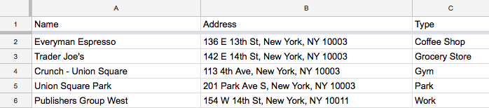
The first step towards creating your apartment options spreadsheet is to identify your apartment’s distance needs. For instance, do you need your apartment to be within a 15-minute walk to work because you get grumpy in the mornings with a long commute in the car? Is there a specific location, such as your favorite grocery store that would be convenient to have nearby? What about that little coffee shop you go to on your days off? Start out by identifying these distance needs, and then input your two or three most frequented places into an Excel or Google spreadsheet.
Interactive Maps Made Easy
Sign Up NowWhen putting your two or three most frequented locations in your spreadsheet, be sure to include columns for the name of the place, the address, and the type of place it is. The type will be useful when sorting your map later. Your spreadsheet should look something like this:
Add Your Apartment Options to Your Spreadsheet
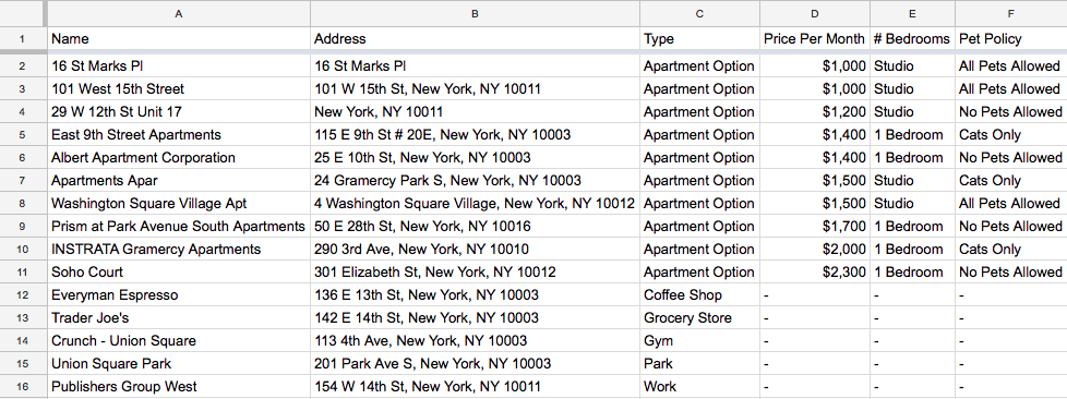
After you’ve added in all of your important locations to your spreadsheet, you can start adding in your apartment options. Here is where you can include details about the apartment itself, including rent price, how many bedrooms it has, or if it’s a studio, and whether or not pets are allowed.
Be sure to assign a type to your apartments just like you did with your important locations. Something like “Apartment Option” will allow you to easily sort out your apartment options from your frequently attended locations later on in the map. When you’ve successfully added in all of the apartments you’re considering, your spreadsheet will look something like this:
Now, just simply copy and paste your data into BatchGeo.
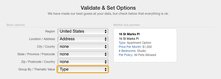
Map It & Group By Type
Once you’ve copied and pasted your apartment data into BatchGeo, click on Map Now to easily map your data. From there, be sure to group your data by “Type.”
This way, you can easily sort your data once your map is complete. Next, just click on Make Map to map your data. Your map will look something like this:
View N.Y.C. Apartment Hunting in a full screen map
Visually, you can see the distances between your apartment options in one color, and your most frequented places in the other colors. We added a park and a gym for good measure.
Location, Location, Location: How to Measure Distance
What’s more, though is that you can do more than just eyeball how close your favorite apartment option is to your work. With BatchGeo, you can actually calculate distances between two addresses or points.
In order to do so, when you’re mapping your data, simply:
Click Validate and Set Options and click on Advanced Options. Then, check the option to calculate distance from the first address and select the units. We picked miles. Click Make Map. Our first address was work, and so BatchGeo will automatically calculate just how far every other item on the spreadsheet is from our work. When your spreadsheet is comprised of ten different apartment possibilities, this can be incredibly useful to get a sense of just how far you’ll be walking or driving every weekday.
More Measurement Options
There is one more way BatchGeo can help to make your moving process go as smooth as possible, and it’s related to, you guessed it, location once again. In the event that you don’t want to only know the distance of everything on your map to your work, BatchGeo also gives you the opportunity to measure on the fly. Simply click on the little ruler in the top left corner of your map:

And select the measuring tool. From here, you can draw a line to each point and BatchGeo will let you know how far they are apart. To change the unit of measurement, click the scale on the bottom right of your map. This feature is only available in BatchGeo’s Advanced Mode, which can add even more insights to your map. Advanced Mode is only available if you are a BatchGeo Pro member.
Before you make your apartment decision based on how much you just want this to be over with, take five minutes to make apartment hunting easier and map it out! And, if you’re done with living in apartments and are in the market to buy a home, check out how to make an open house map.
