36 Hours of #love: Map Twitter and Instagram Hashtags
The pulse of the planet beats through Twitter, where a cross-section of the world shares what’s on their minds. As we celebrate Valentine’s Day, let’s listen into a few of those hearts through a simple hashtag. We grabbed a sampling of tweets including the #love hashtag over a 36 hour period, then filtered down to those that sent geographic coordinates. The result is this map of sentimental moments all over the globe.
View 36 Hours of #love Map in a full screen map
From Canadians missing family to Australians at the beach (it is summer down there), everyone is sharing their love for something or someone. Even though these are all tweets, they’re also Instagram photos. The popular pic-sharing app makes it really easy to geocode your shots, as well as share on Twitter, so it’s no surprise to see it show up in our #love data.
Some of these stories of love are explained within the text itself. Others are a little slice of mystery. For example, it’d be fun to know the story behind how a picture from a flight was plotted in northern Canada—someone didn’t put their device in airplane mode, I guess. Or, how is there only one tweet from San Francisco? Perhaps the tech industry is over hashtags, or love, or both.
Map Your Own Twitter Search
With thousands of tweets every second, this map likely didn’t catch every single #love tweet, but we gathered nearly 7,000 over a day and a half. Most of these tweets did not have the precise location embedded, but many are still mappable. Here’s how you can make your own Twitter Search Map:
- Install the Twitter Archiver plugin for Chrome
- In a new Google Spreadsheet, go to the Add-ons, choose Twitter Archiver, then Create Search Rule
- Add your search criteria—there are a lot of potential options.
- Click the Start Tracking button.
After giving access to your Twitter account (it won’t post anything), you’ll start getting data in a new sheet Twitter Archiver creates. You’ll get a lot of results at first, then start receiving up to 100 per hour. It keeps working even with your computer off or the spreadsheet closed.
Interactive Maps Made Easy
Sign Up NowNow you have a spreadsheet with tweets matching your search term. BatchGeo does a great job of converting spreadsheets to maps, so grab the columns of the data that you want to include on your map.
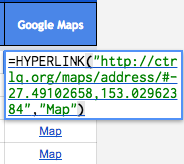 If a tweet has a precise location, you’ll see a “Map” link in the last column of your spreadsheet. To retrieve the latitude and longitude requires either some manual effort or coding on your part, unfortunately. You can see in the image that by double-clicking a Map cell, embedded within are geographic coordinates.
Alternatively, you can use the location column to let BatchGeo perform the geocoding. It’s not as precise, since it will map whatever the user has as their location in their bio, but it’s still an interesting look at tweets by place. Also, you’ll likely have much more data this way.
No matter what type of data you have, from Twitter or from your hard drive, we hope you #love BatchGeo. If you haven’t checked us out yet, create a map today.
