Mapping the Busiest Ports Worldwide

In the days of world exploration, ships were the way to we discovered new land, new routes, and anything new. Then ships became the primary method of long distance transportation, and remained that way for centuries. These days, cruises take those who can afford the luxury on purposefully slow-paced journeys. Yet, another type of ship continues to rule the sea. In fact, an entire industry is named after it: shipping.

View Busiest Container Ports in the World in a full screen map

On the map above, you can find the 50 busiest ports in the world across 30 countries. What does busy mean? It’s measured by thousands of “TEUs,” twenty-foot equivalent units. A TEU is the equivalent of a single shipping container, the metal structures stacked on large ships and shuttled across the oceans.

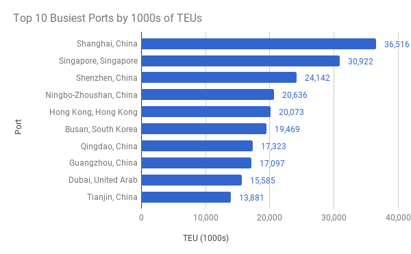
Perhaps unsurprisingly, six of the top 10 ports are in China. Shanghai is number one, by over 5 million containers. China’s largest city has been top since 2010, when it surpassed Singapore (now number two). China’s other cities in the top 10 are Shenzhen (3), Ningbo-Zhoushan (4), Qingdao (7), Guangzhou (8), and Tianjin (10). The other non-Chinese ports in the top 10 are Hong Kong (5); Busan, South Korea (6), and Dubai, United Arab Emirates (9).

Officially, Hong Kong is an administrative region of China, after being transferred from British rule in 1997, though Hong Kong operates with a high degree of autonomy. As recently as 2004, Hong Kong was the busiest container port in the world. While others in the top 10 have seen tremendous growth, Hong Kong actually has seen less traffic in its port over the recent years.

In the last 10 years, Shanghai container ship traffic has more than doubled, a considerable feat for a city already high on the list. By comparison, Singapore and Shenzhen have seen 33% and 49% growth respectively. Ningbo-Zhoushan, another China powerhouse, was #15 on the list a decade ago. It has moved up the list by seeing its volume nearly quadruple during that short time. Other ports that have at least doubled in the last 10 years are Balboa, Panama (364%); Guangzhou (265%); Dalian, China (260%); Ho Chi Minh City, Vietnam (209%); Tianjin (189%); Xiamen, China (176%); Qingdao (175%); Khor Fakkan, United Arab Emirates (129%); Port Klang, Malaysia (114%); Tanjung Pelepas, Malaysia (111%); and Dubai (105%).

Indeed, China is seeing a lot of growth despite already being a stronghold of busy ports. In fact, the country tally amongst these top 50 ports puts China at nearly five times the container volume of the next-most, Singapore. Rounding out the top five are the United States, Malaysia, and Hong Kong.

The overall Chinese growth rate over the last five years is only 34%, so on the short term there are smaller players that have gained ground faster. Greece, whose port city of Piraeus only saw 665,000 containers in 2010 was nearing 3.4 million in 2015, the latest data available. That puts Greece at over 400% growth, quintupling container volume in five years. Other fast-growing countries didn’t even double. Rounding out the top five are Vietnam (60%), Morocco (44%), Saudi Arabia (41%), and Brazil (39%).

A few of these countries with ports in the top 50 have seen negative growth in the last five years: Egypt (-17%), Hong Kong (-15%), and Japan (-3%). In the case of Japan’s four top port cities, only Nagoya has seen growth.

Wait, What’s a Shipping Container?

With all this talk about containers and the twenty-foot equivalent unit (TEU), it can be tough to picture exactly how much fits in a container. And for that matter, how many of these TEUs fit on a single ship?

Despite the official-sounding name, TEU, there actually isn’t a standard size for a shipping container. Most are 20 feet long, which is where that name comes from, but the height varies. Most are eight and a half feet tall, though others are nine and a half feet. Rarely there are some half-height containers that are four feet three inches tall. Confusingly, these all count as one TEU.

It gets more confusing. Remember when I said most are 20 feet long? Well, some are 40 feet long, so these are counted as two TEUs. Others are 45 feet long, and they are still counted as only two TEUs rather than 2.25 TEUs.

These factors complicate how much can fit in a single container, as well as how many containers fit on a ship. However, if we go with the most popular 20 feet by 8.5 feet, we end up with 1,360 cubic feet (strangely, for all the other variations, most shipping containers are eight feet wide).

How many containers can fit on a ship depends, obviously, on the size of the ship. A common class of container ship, the Panamax, is so-named because it’s the largest ship that can fit through the original Panama Canal. These ships hold 3,000-5,000 TEUs. A larger ship class, the Post-Panamax, can fit through the Panama Canal expansion, and holds 10,000-15,500 TEUs.

As for how much fits in a single container, that also depends on what you’re transporting, and how well you store it. There are currently two answers to a Quora question about coconuts, with one estimate two times as big as another. Yet, according to iContainers, a 20 foot container can hold 48,000 bananas, 400 flat screen TVs, or 200 full size mattresses.

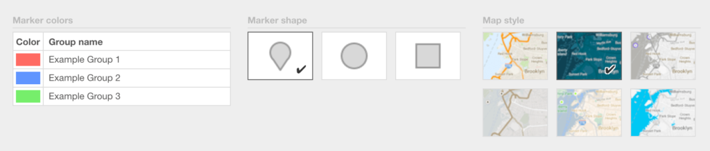
Make Your Own Map With Wikipedia Data

This post is based on data in a Wikipedia article. Often this data is best shown as a map!

Check out our Open Data Map Tutorial and build one like this yourself!

Make Maps into Static Images

In a single image, maps can communicate a lot about the world around us. Whether it’s directions from point A to point B, or a glimpse at all of your customers in a region, a map tells a story. Like the picture that’s worth 1,000 words, a map can be the same. And while we obviously love interactive maps, there are situations where a static map image does as good or better.

For example, say you want to embed a map on Facebook or Twitter or even email. An interactive map won’t work there, for technical reasons. Instead you need an image version of the map. There are several services that can generate maps, complete with marker icons, into static images. In this post, we’ll share several of these options and discuss the pros and cons of each.

Differences in Static Map Generators

We’ll go into detail about each of the map generators in the next sections, but first it’s good to get an idea of the common themes. There are three main areas to consider when comparing static map generators:

  • How data is sent: In many cases you need to know the map coordinates, the latitude/longitude pairs that describe a location on a map. However, others allow you to send the human-readable names or addresses, and do the geocoding conversion to coordinates for you.
  • Style of the maps: Usually the ways the maps and markers look are already decided for you by the mapping provider. However, in a couple circumstances you can customize the look. The tradeoff, of course, is in complexity and the time it takes to set up.
  • Requirements: While every provider mentioned here offers free versions, some have advanced features available for a cost. And, in many cases, even the free versions require you to register for an account and/or an “API Key,” that identifies your static map requests as yours.

With these issues covered, we’ll get into what’s possible with each of these static map generators.

BatchGeo

Every interactive map made with BatchGeo also has a corresponding static map badge, an image you can use with or without the larger map. There are no API Keys or URL patterns required, though you do need to use the BatchGeo editor to make updates to your image map.

To create a map, follow these steps:

  1. Paste your spreadsheet data into the map builder and make sure to enter your email address when saving.
  2. You should receive an email shortly after saving your map with details on how to edit it.
  3. Click to the edit link, and scroll down to the “map badge” code section.
  4. Copy/paste the code onto your web page, you are done!

The image itself does have a few optional tweaks you can make to the URL, which looks like this:
https://static.batchgeo.com/map/png/?i=national-parks&width=284&height=142

To adjust the size or shape of the image, just change the width= and height= fields in the URL before saving the file.

BatchGeo also includes a number of ways to customize the style of your map. When creating your map, choose “Validate and Set Options,” then select “Advanced Options” to change the color and shape of the markers, as well as select from six underlying map styles.

Google

The de facto choice for interactive maps also has static image mapping available. While the search giant refers to this tool as the Static Maps API, it’s not an API in the usual tech sense. That’s because you can use it without writing a single line of code. Rather, all of the inputs needed to create a static map with Google come through the URL.

Consider the above image, which was generated from this URL:
https://maps.googleapis.com/maps/api/staticmap?center=37.819722,-122.478611&zoom=12&size=400×300&markers=37.819722,-122.478611&markers=37.799,-122.4664

Each parameter can be changed and will update the map in some way. While this example uses latitude and longitude coordinates, one of the best features of Google’s static maps are the built in geocoding. For example, here is the URL for a similar map, using human-friendly values:
https://maps.googleapis.com/maps/api/staticmap?center=Golden+Gate+Bridge+San+Francisco+CA&zoom=12&size=400×300&markers=Golden+Gate+Bridge+San+Francisco+CA&markers=Presidio+San+Francisco+CA

The result is a bit longer, but much easier to update. While this example uses two landmarks, you can also use city names, postal codes, and full addresses, right in the image URL.

In addition, Google supports a bunch of advanced features, like marker colors, marker labels, and entire map style changes. Everything can be set from the URL, though for these more advanced uses, you’ll definitely need an API Key to identify yourself. You can find out more about all of this in Google’s documentation.

MapBox

MapBox is a lesser-known mapping provider that also appeared on our list of 3 ways to style maps. While its speciality is extremely customized control of how the map looks, including the ability to bring your own underlying data, it also has a static map service for its stock data.

The above image, similar to the Google example, was generated with this URL:
https://api.mapbox.com/styles/v1/mapbox/streets-v10/static/pin-m(-122.478611,37.819722),pin-m(-122.4664,37.799)/-122.478611,37.819722,11/400×300?access_token=TOKEN

All aspects of the map are generated from the data passed in the URL. If you look closely, you’ll find the center of the map, the points for the two markers, the zoom level, and the size of the image. Unlike Google’s states maps, MapBox does not use URL fields, but rather its own format of describing points, paths, and other “overlays” (mapping speak for any objects that can be added atop the base map). MapBox also supports an advanced overlay format in GeoJSON, a standard popular in web cartography circles.

Something to note about MapBox that is different from all the other providers: the coordinates to designate a place must be passed in “longitude,latitude” order. If you get that wrong, you could find yourself in the wrong quadrant of the world (or with an error about latitude out of range).

Looking at that URL, you may have also noticed the access_token field. MapBox requires an API key. With a free MapBox account, you can retrieve a public token here.

Of course, as you would expect with the customizability of MapBox, you can load any styles stored in your account. You can find all the options and details in the full documentation.

MapQuest

Are you surprised that this map granddaddy has a static map offering? Yes, the original web map has a robust developer platform, including interactive maps. While the underlying map cannot be changed, there are still many options available that make MapQuest a contender.

To generate the map above, use this simple URL:
https://www.mapquestapi.com/staticmap/v4/getmap?size=400,300&pois=default,37.819722,-122.478611|default,37.799,-122.4664&key=KEY

One thing MapQuest has going for it is smart defaults. When a map contains markers (which it calls POIs—points of interest), a center and zoom level are not needed. In fact, in our tests, the center field is ignored in favor of a centroid calculated from the markers on the map. This ensures that everything meant to be visible is part of the image. Other providers have this option, but it’s a requirement with MapQuest.

As with others, you can see that the API Key is a requirement. There are generous free limits available once you create an API Key.

Among the features most interesting in MapQuest is marker labels. You can replace “default” in the URL above to get any number of letter you want in the marker. Other customization options and examples are available in the documentation.

Bing Maps

Don’t count Microsoft out of this mapping fun. Through its search brand, Bing, there is an API for Bing Maps. Among the options in the Bing Maps suite is static maps.

That map looking familiar yet? Here’s how you can create it with Bing Maps:
http://dev.virtualearth.net/REST/v1/Imagery/Map/Road/37.819722,-122.478611/12?mapSize=400,300&pushpin=37.819722,-122.478611&pushpin=37.799,-122.4664&key=KEY

While not called out as fields, the map type, center location, and zoom level are all included before the question mark in the URL. Like Google, you set multiple markers by duplicating the field (in this case, called “pushpin”). There are additional marker options to change the style and add labels.

Again, with Bing you’ll need an API Key. You can register and create one for free using the Bing Maps Portal. For all the various options available, see Bing’s static maps documentation.

Comparison Table

Feature BatchGeo Google MapBox MapQuest Bing
Human-readable names Yes Yes No No No
Coordinates style Two columns Lat,Lng Lng,Lat Lat,Lng Lat,Lng
Change map style Yes Yes Yes No No
API Key required Never Sometimes Always Always Always
Spreadsheet upload Yes No No No No

Beautiful, High Resolution, Printable Maps

Static maps are a great choice for websites where you don’t need interactivity, but you want to communicate the locations. You can also reuse them in social media, emails, and other places where interactive maps are not possible. Yet, sometimes what you need is something in higher resolution. For example, you may want to print a map or share a high quality PDF.

Every BatchGeo Pro account comes with unlimited high resolution maps for you and your entire team. Plus, you get lightning-fast map creation with support for interactive and static maps with up to 20,000 locations. Try it now!

Your Map Data To Go On Any iPhone or iPad

Wherever you are, you can view, filter, and search your maps faster than ever before. We have completely updated BatchGeo Mobile, our native iOS app for accessing your maps. You can now use any iOS device and see the same great interface to your map data that you’ve come to expect with BatchGeo.

BatchGeo Mobile features

Among the improvements we’ve added to BatchGeo Mobile are:

  • Updated to support the latest versions of iOS 10
  • Added Google Maps rendering for a consistent, fast look
  • Included our advanced mode features like heat map and data view

The latest enhancements for BatchGeo Mobile make it an even better choice for on-the-go maps. Use the GPS-enabled app for customer visits, sales maps, or other data you want to access anywhere.

Google Maps: Filter, Zoom, Select

As with the web version of BatchGeo, the iOS app now is built upon the industry-leading Google Maps platform. We’ve taken a speed-first approach, ensuring you can see your map and data as quickly as possible. To orient you easily, we’ve modeled the interface after the web version, so you know exactly how to use your data, no matter where you are.

BatchGeo Mobile filter options

Use the powerful grouping feature to drill down at a specific subset of your data. Non-location columns in your spreadsheet are available to filter your map by category values or numeric ranges. Maps with thousands of locations can keep you focused when you select just the fields you need to see in the moment. Pair this with your current GPS location, and you’ll see what’s important in any locale.

Find your nearest marker, search across the data, or drag and zoom your way to what you seek. Tap a marker to see its underlying data. BatchGeo Mobile means fast access to your own data.

BatchGeo Pro: Advanced Mode for Your Whole Team

The new version of BatchGeo Mobile also makes our popular advanced mode available on your iOS device. Visualize your data with heat maps, a layer that shows the density of your markers to show the “hot spots.” Or check out the details in your data with a spreadsheet-like view that takes you to each location in a click.

BatchGeo Mobile Advanced Tools: Heat Maps and Data View

You may have noticed that maps with many markers end up communicating density through the overlap of markers. Additionally, you can use clustering to aggregate and visualize underlying data. But neither of those quite get the story within the data across like a heat map. Our algorithm calculates the areas of highest density, then layers a partially-transparent visual over the map so you can see the underlying areas. Our customers frequently identify new insights with this view at their own data.

On the other end of the spectrum is data view, which helps BatchGeo Pro users dig into the details within their data. Use data view to take a quick look into tabular data akin to a spreadsheet. Sort by any field to find the best and worst in a category, then tap a row to see it quickly appear on the map above.

To turn on either of these features, tap and hold on your map, then select the option you’d like to enable. Inspect your locations with data view and make it come to life with heat maps.

Share Maps Across Web and Mobile

We think you’ll enjoy BatchGeo Mobile so much, you’ll want everyone on your team to see the world the way you do. That’s why we’ve built sharing into the app from the start. Some improvements in the latest version make it even more useful.

BatchGeo Mobile Sharing

Filter your map list to distinguish your personal maps from those the rest of the team is sharing. That way, you always know whose map is whose.

Even better, sharing maps with others is simpler than ever. Now BatchGeo Mobile supports both email and the native iMessage platform to send links to shared maps. You’ll save your team time and always have maps at your fingertips.

Try BatchGeo Mobile Today

BatchGeo Mobile is faster than ever, with a consistent look powered by Google Maps. Take advantage of grouping data, heat mapping, sharing, and more. Download BatchGeo Mobile today and access your maps wherever you go.