Advanced Mode Adds Even More Insights to Your Maps
Your maps help you understand your data. They tell a story that a standard spreadsheet just doesn’t make possible. With our new Advanced Mode, we’ve enhanced the visual map by selectively exposing the data it contains. You can use sort, select, and copy any of your data in spreadsheet-like format. We’ve also included visual selection tools (rectangles and circles), as well as a handy distance measuring tool. BatchGeo’s Advanced Mode is available to all Pro users. We think it’s so useful that we’ve switched it on by default (you can adjust this in the Pro menu in the upper right corner of any map).
Data Sorting, Selecting, and Copying
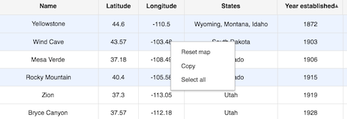
At the heart of Advanced Mode is the Data View, which can be activated from the context menu by right clicking on the map. The height-adjustable table looks a lot like a spreadsheet. It also acts a lot like a spreadsheet, allowing you to sort columns and select rows. Then you can copy the selected data to paste back into a spreadsheet or use as a new BatchGeo map.
To sort, click a column heading. To reverse the sort order, click again. When you’re ready to select several rows, click and drag to highlight them all—you may see the map view change in response as it displays those you’ve selected. To select (or un-select) one at a time, hold Ctrl (Cmd on Mac) and click on the desired row.

When you’re ready to copy your selected data, just activate the context menu with a right click above the data view and choose Copy.
Select Visually Using the Drawing Tools
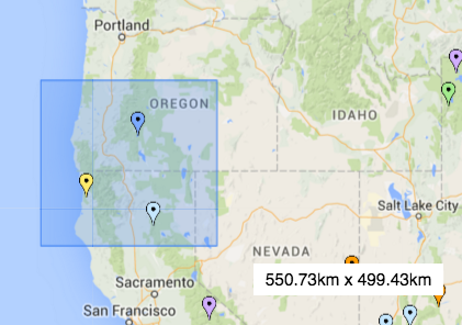
Sorting and selecting via the Data View will likely feel familiar to working with spreadsheets. You can also highlight the map geographically, with your selection translating to the table below. The drawing tools in the upper left of the map bring the power of visual selection to your data view. Use the rectangle and circle tools to choose just the markers you want to include. Then copy them as you would when selecting data in the table itself.
Interactive Maps Made Easy
Sign Up Now
To select using the bounding box, choose the rectangular tool icon. Position your cursor to one of the corners of the area you want to select. Then click and hold your mouse while you draw the box around the markers you want to select. The circle tool is similar, but instead of starting at one corner, you begin in the middle of your selection. In both cases, you can hold shift while selecting to extend your selection.
In addition to visual and data selection, there are two other features of Advanced Mode we want to point out.
View Heat Maps to Expose Marker Density
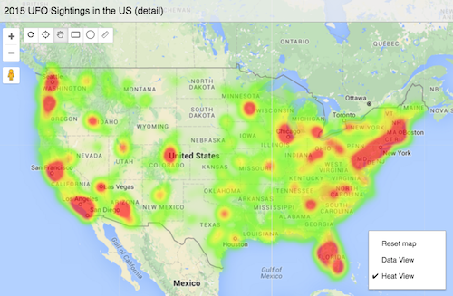
There are already a number of ways to visualize the density of locations using a BatchGeo map. Since we display all the markers, more in one area will naturally cause them to overlap. You can also use our map clustering feature, which is a great way to share the data within your map publicly. As part of Advanced Mode, we’ve added heat maps, which gives any Pro user the ability to toggle a heat map view of the geographic data.

To activate the Heat View, just select it in the context menu with a right click above the map. Once activated, it will become your own personal default view on any map until you deactivate it using the same context menu on any map. The Heat View will only be visible to users that are part of your Pro plan using the web interface, and only if they use the same menu to activate.
Heat View is the best way to visualize the density of locations to uncover the story within your data. We think you’ll like it.
Calculate the Distance Between Markers
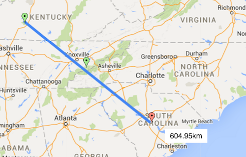
Finally, a fun little feature that we’ve found surprisingly useful. How many times have you wanted to know the distance between points on your map, or how far a marker is from a landmark? This happens to us all the time, so we added another tool to calculate on the fly.

Select the little ruler icon in the upper left menu. Then click and hold where you want your line to start. As you drag the cursor, you’ll see the distance displayed. It uses a straight, as-the-crow-flies calculation. You can take as many measurements as you like, and let go of the mouse click whenever you’re done.
Uncover More in Your Maps
We’ve heard from other BatchGeo Pro members that these tools help them find more value within their data. You can zero in on the customers, leads, or other location data that is important in the moment. The new Data View allows for easily exporting subsets of your spreadsheets, with the visual selection bringing brand new ways to geographically slice and dice your data.
Let us know what you think. If you haven’t yet, you can upgrade to Pro with our no-risk 30-day refund guarantee.
